
Atlantic Ocean facts for kids
| Earth's oceans (World Ocean) |
|---|
|
|


The Atlantic Ocean is the world's second largest ocean. It covers a total area of about 106,400,000 square kilometres (41,100,000 square miles). It covers about 20 percent of the Earth's surface. It is named after the god Atlas from Greek mythology. Its name means "Sea of Atlas."
Geologic history
The Atlantic formed when the Americas moved west from Eurasia and Africa. This began sometime in the Cretaceous period, roughly 135 million years ago. It was part of the break-up of the supercontinent Pangaea.
The east coast of South America is shaped somewhat like the west coast of Africa, and this gave a clue that continents moved over long periods of time (continental drift). The Atlantic Ocean is still growing now, because of sea-floor spreading from the mid-Atlantic Ridge, while the Pacific Ocean is said to be shrinking because the sea floor is folding under itself or subducting into the mantle.
Geography
The Atlantic Ocean is bounded on the west by North and South America. It connects to the Arctic Ocean through the Denmark Strait, Greenland Sea, Norwegian Sea and Barents Sea. It connects with the Mediterranean Sea through the Strait of Gibraltar.
In the southeast, the Atlantic merges into the Indian Ocean. The 20° East meridian defines its border.
In the southwest, the Drake Passage connects it to the Pacific Ocean. The Panama Canal links the Atlantic and Pacific.
The Atlantic Ocean is second in size to the Pacific. It occupies an area of about 106,400,000 square kilometres (41,100,000 sq mi). The volume of the Atlantic, along with its adjacent seas (the seas next to it), is 354,700,000 cubic kilometres.
The average depth of the Atlantic, along with its adjacent seas, is 3,339 metres (1,826 fathoms; 10,955 ft). The greatest depth is Milwaukee Deep near Puerto Rico, where the Ocean is 8,380 metres (4,580 fathoms; 27,490 ft) deep.
Gulf Stream
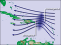
The Atlantic Ocean has important ocean currents. One of these, called the Gulf Stream, flows across the North Atlantic. Water gets heated by the sun in the Caribbean Sea and then moves northwest toward the North Pole. This makes France, Ireland, Britain, Iceland, and Norway in Europe much warmer in winter than Newfoundland and Nova Scotia in Canada. Without the Gulf Stream, the climates of northeast Canada and northwest Europe might be the same, because these places are about the same distance from the North Pole.
There are currents in the South Atlantic too, but the shape of this sea means that it has less effect on South Africa.
Geology
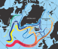
The main feature of the Atlantic Ocean's seabed is a large underwater mountain chain called the Mid-Atlantic Ridge. It runs from north to south under the Ocean. This is at the boundary of four tectonic plates: Eurasian, North American, South American and African. The ridge extends from Iceland in the north to about 58° south.
The salinity of the surface waters of the open ocean ranges from 33–37 parts per thousand and varies with latitude and season.
- 0°N 30°W / 0°N 30°W
Images for kids
-
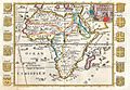
The Aethiopian Ocean in a 1710 French map of Africa
-
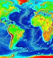
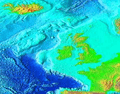
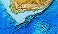
False color map of ocean depth in the Atlantic basin
-
As the Gulf Stream meanders across the North Atlantic from the North American east coast to Western Europe its temperature drops by 20 °C (36 °F).
-
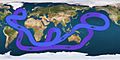
Path of the thermohaline circulation. Purple paths represent deep-water currents, while blue paths represent surface currents.
-
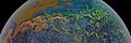
In the subpolar gyre of the North Atlantic warm subtropical waters are transformed into colder subpolar and polar waters. In the Labrador Sea this water flows back to the subtropical gyre.
-
Waves in the trade winds in the Atlantic Ocean—areas of converging winds that move along the same track as the prevailing wind—create instabilities in the atmosphere that may lead to the formation of hurricanes.
-
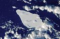
Iceberg A22A in the South Atlantic Ocean
-
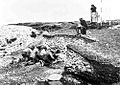
Excavation of the Ertebølle middens in 1880
-
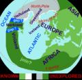
Based on the medieval Íslendingasögur sagas, including the Grœnlendinga saga, this interpretative map of the "Norse World" shows that Norse knowledge of the Americas and the Atlantic remained limited.
-
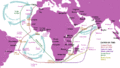
The Atlantic Gyres influenced the Portuguese discoveries and trading port routes, here shown in the India Run ("Carreira da Índia"), which would be developed in subsequent years.
-
Embarked and disembarked slaves in the Atlantic slave trade 1525–1863 (first and last slave voyages)
-
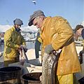
Cod fishery in Norway
-
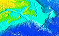
Banks of the North-East Atlantic
-
Banks of the North-West Atlantic
-
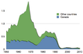
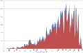
Capture of Atlantic north-west cod in million tons
-
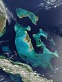
Bahama Banks
-
Agulhas Bank
-
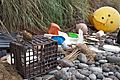
Marine debris strewn over the beaches of the South Atlantic Inaccessible Island


.jpg)
See also
 In Spanish: Océano Atlántico para niños
