
Central Coast (California) facts for kids
Quick facts for kids
Central Coast
|
|
|---|---|
|
Region
|
|

South Coast of Santa Barbara County
|
|

|
|

Sunset at Salinas River State Beach in Monterey County
|
|
| Country | United States |
| State | California |
| Population | 2,249,558 (All 6 counties combined) |

The Central Coast is an area of California, roughly spanning the coastal region between Point Mugu and Monterey Bay. It lies northwest of Los Angeles County and south of San Mateo and Santa Clara counties, and includes the rugged, undeveloped stretch of coastline known as Big Sur. From south to north, there are six counties that make up the Central Coast: Ventura, Santa Barbara, San Luis Obispo, Monterey, San Benito, and Santa Cruz.
The Central Coast is the location of the Central Coast American Viticultural Area.
Geographically, the actual midpoint of the California coast lies north of Santa Cruz, near Año Nuevo State Park in San Mateo County. Neither the popular use of the term Central Coast nor that of the California North Coast include the San Francisco Peninsula counties of San Mateo and San Francisco.
History
The Central Coast area was originally inhabited by Chumash and other Native American people since at least 10,000 BC. Many of these settlements were coastal, where the people exploited marine resources and dwelt near freshwater inflows to the Pacific Ocean. For example, there were significant settlements near the mouth of Morro Creek and Los Osos Creek.
Juan Rodríguez Cabrillo visited the Central Coast, landing in Santa Barbara County in 1542, having sailed from the south.
Overview

The region is known primarily for agriculture and tourism. Major crops include wine grapes, lettuce, strawberries, and artichokes. The Salinas Valley is one of the most fertile farming regions in the United States. Tourist attractions include Cannery Row in Monterey, the Monterey Bay Aquarium, the theatres, galleries and white sand beaches of Carmel-by-the-Sea, the golf courses of Pebble Beach and the Monterey Peninsula, the rugged coastline of Big Sur and Hearst Castle in San Simeon.
The area is not densely populated. The largest city in the region is Oxnard in Ventura County, with a population estimated at 203,007 in 2013. University of California campuses are found in Santa Barbara and Santa Cruz, on the extreme south and north edges of the region respectively. California State University, Monterey Bay, founded in 1994, uses facilities donated when Fort Ord was converted from military to civilian uses. California Polytechnic State University, in San Luis Obispo, was founded in 1901.
Population
The six counties that make up the Central Coast region had an estimated population of 2,327,344 in 2014, about 5% more than the population of New Mexico.
Counties by population
| County |
FIPS code | County seat | Established | Formed from | Etymology | Population | Area | Map |
|---|---|---|---|---|---|---|---|---|
| Ventura County | 111 | Ventura | 1872 | Santa Barbara | The city of Ventura, itself an abbreviation of San Buenaventura, Spanish for St. Bonaventure. | 846,178 | 1,846 sq mi (4,781 km2) |
 |
| Santa Barbara County | 083 | Santa Barbara | 1850 | Original | The city of Santa Barbara, itself Spanish for Saint Barbara. | 440,668 | 2,738 sq mi (7,091 km2) |
 |
| Monterey County | 053 | Salinas | 1850 | Original | Monterey Bay, itself a Spanish portmanteau of monte ("hill") and rey ("king"). | 431,344 | 3,322 sq mi (8,604 km2) |
 |
| San Luis Obispo County | 079 | San Luis Obispo | 1850 | Original | The city of San Luis Obispo, itself Spanish for Saint Louis, the Bishop. | 279,083 | 3,304 sq mi (8,557 km2) |
 |
| Santa Cruz County | 087 | Santa Cruz | 1850 | Original | The city of Santa Cruz, itself Spanish for holy cross | 271,804 | 446 sq mi (1,155 km2) |
 |
| San Benito County | 069 | Hollister | 1874 | Monterey | Saint Benedict (San Benedicto in Spanish; Benito is the diminutive of Benedicto). | 58,267 | 1,389 sq mi (3,597 km2) |
 |
Travel
Travel is almost entirely by private automobile. Because of its position roughly halfway between the major cities of Los Angeles and San Francisco, San Luis Obispo is home to America's first motel. The major highway is U.S. Route 101, which runs north-south from Los Angeles, through most of the major communities of the Central Coast, to San Francisco. State Route 1, a smaller but much more scenic route, connects the coastal communities, running through San Simeon, Morro Bay, and Big Sur. Amtrak maintains train service with the Coast Starlight and Pacific Surfliner routes along the Union Pacific Railroad Coast Line that also transports freight. There are no major airports, although Monterey, Santa Barbara, Santa Maria and San Luis Obispo have regional airports with commuter service. Greyhound buses serve most of the region.
Monterey-Salinas Transit (MST) operates bus services throughout Monterey County as far south as Big Sur on the coast and King City in the Salinas Valley. MST also offers connection service to San Jose Diridon Station, downtown Santa Cruz, and Paso Robles and Templeton in Northern San Luis Obispo County via regional routes. Santa Cruz Metro Offers services within Santa Cruz County, including connections to San Jose and San Jose State and connection to MST service in Watsonville, heading south to Salinas.
Transportation
Travel is almost entirely by private automobile. Because of its position roughly halfway between the major cities of Los Angeles and San Francisco, San Luis Obispo is home to America's first motel. The major highway is U.S. Route 101, which runs north-south from Los Angeles, through most of the major communities of the Central Coast, to San Francisco. State Route 1, a smaller but much more scenic route, connects the coastal communities, running through San Simeon, Morro Bay, and Big Sur. Amtrak maintains train service with the Coast Starlight and Pacific Surfliner routes along the Union Pacific Railroad Coast Line that also transports freight. There are no major airports, although Monterey, Santa Barbara, Santa Maria and San Luis Obispo have regional airports with commuter service. Greyhound buses serve most of the region.
Monterey-Salinas Transit (MST) operates bus services throughout Monterey County as far south as Big Sur on the coast and King City in the Salinas Valley. MST also offers connection service to San Jose Diridon Station, downtown Santa Cruz, and Paso Robles and Templeton in Northern San Luis Obispo County via regional routes. Santa Cruz Metro Offers services within Santa Cruz County, including connections to San Jose and San Jose State and connection to MST service in Watsonville, heading south to Salinas.
Images for kids
-
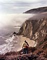
Big Sur, California
.jpg)
