
Amazon River facts for kids

The Amazon River (also named Rio Amazonas in Portuguese and Spanish) is the largest river in the world by the amount or volume of water it carries. It flows through the tropical forests of South America, mainly in Brazil. Its headwaters are in the Andes Mountains in Peru, on the western edge of South America and flows eastward into the Atlantic Ocean near the equator.
The Amazon River moves more water than the next eight largest rivers of the world combined and has the largest drainage basin in the world. It accounts for about one fifth of the world's total river flow. During the wet season, parts of the Amazon exceed 120 miles (190 km) in width. Because of its size, it is sometimes called The Sea, but it is not the world's longest river system. The world's longest river is the Nile River, with the Amazon being second-longest.
Size and path

It is one of the longest rivers in the world. There have been different studies that have tried to measure its exact length. As the studies have come up with different numbers, it is therefore difficult to give an exact number. The length also changes in the rainy season. Several studies from Brazil, Spain and Chile say it is the longest river in the world, longer than the Nile. The Nile has a length of 6,571 kilometres (4,083 mi). The Amazon may have a length of 6,937 km (4,310 mi). The Spanish daily newspaper El País gives its length at 6,850 km (4,260 mi). In 2007, scientists from Peru and Brazil calculated a length of 6,800 km (4,200 mi).
A study done in 1969 says that the Amazon has a length of 6,448 km (4,007 mi). This was measured from a part of the River Apurimac. Until the 1970s, it was thought that the Marañón River was the source of the Amazon. In 2001, an expedition found that Nevado Mismi was in fact the source of the Amazon. Another document of the Geographic society of Lima gives the length of the Amazon at over 7,000 km (4,300 mi).
The source of the Amazon is in the Andes Mountains of western South America. It flows east from there to the Atlantic Ocean. Most of the huge river and its many tributaries are in the country of Brazil. There are many places on the Amazon where a person on one side of the river cannot see the other side. The Brazilians call the Amazon the "River Sea." The Amazon is navigable from the ocean to Peru. Ocean ships can travel on the Amazon all the way across Brazil, and most of South America, to the city of Iquitos in Peru.
One characteristic of the Amazon river is the Brazo Casiquiare, a water connection to the Orinoco river into Venezuela, that connects the two basins.
Estuary

The estuary of the Amazon is about 330 km (205 mi) wide. The width of the mouth of the river is usually measured from Cabo do Norte to Punto Patijoca. Generally, the outlet of the Para River is included. It is 60 km (37 mi) wide, and forms the estuary of the Tocantins. The estuary also includes the island of Marajó, which lies in the mouth of the Amazon. This means that the Amazon is wider at its mouth than the entire length of the Thames river in England.
Along the coastline, near Cabo do Norte, there are many islands partially covered with water. There are also sandbanks. The tides of the Atlantic generate a wave that reaches into the Amazon river. This wave goes along the coast for about 420 kilometres (261 miles). The phenomenon of this wave generated by the tides is called a tidal bore. Locally it is known as pororoca. The pororoca occurs where the water is less than 7 m (23 ft) deep. It starts with a loud noise, and advances at a speed of 15–25 km/h (9–16 mph). The bore is the reason the Amazon does not have a delta. The ocean rapidly carries away the large amount of silt brought by the Amazon. This makes it impossible for a delta to grow past the shoreline. It also has a very large tide, that can reach 6 metres (20 feet). The place has become popular for river surfing.
Uses
The Amazon River has many
- We get hydroelectric power from the river.
- We build dams all along the Amazon river to build up pressure.
- We use it for travel, we send tours down it to get money and we send other types of ships down it.
- The indigenous people carry food down it and canoe down it to trade.
- It is fresh water so animals can drink from it.
- They grow crops on the banks of it.
Bridges
There are no bridges across the entire width of the river. This is not because the river would be too wide to bridge; for most of its length, engineers could build a bridge across the river easily. For most of its course, the river flows through the Amazon Rainforest, where there are very few roads and cities. Most of the time, the crossing can be done by a ferry, so there is no need to build a bridge. The Manaus Iranduba Bridge linking the cities of Manaus and Iranduba spans the Rio Negro (a tributary of the Amazon).
The river is the main route of traffic in the region. Most cities are on the banks of the river. The biggest city on the river is Manaus, which is also the capital of the Brazilian State of Amazonas. Many native people live in the Amazon, such as the Urarina who live in Peru.
Trade route
Big ocean boats can get up the river until Manaus, which is almost 1500 kilometers (900 miles) from its mouth. Smaller ocean ships of 3,000 tons and 7.9 m (26 ft) draft can reach as far as Iquitos in Peru, 3,700 km (2,300 miles) from the sea. Smaller riverboats can reach 780 km (486 mi) higher as far as Actual Point. Beyond that, small boats frequently go up to the Pogo Ode Escherichia's, just above Actual Point.
Images for kids
-
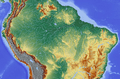
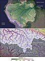
Topography of the Amazon River Basin
-
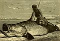
Old drawing (from 1879) of Arapaima fishing at the Amazon river.
-
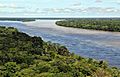
Amazon tributaries near Manaus
-
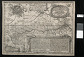
Samuel Fritz's 1707 map showing the Amazon and the Orinoco
-

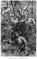
Masked-dance, and wedding-feast of Ticuna Indians, engravings for Bates's 1863 The Naturalist on the River Amazons
-
Henry Walter Bates was most famous for his expedition to the Amazon (1848–1859).
-
Amazonas state
-
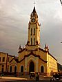
Iglesia Matriz in Iquitos, Peru
-
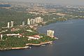
City of Manaus
-
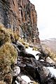
The Amazon was thought to originate from the Apacheta cliff in Arequipa at the Nevado Mismi, marked only by a wooden cross.
-
Nevado Mismi, formerly considered to be the source of the Amazon
-
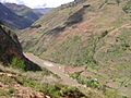
Marañón River in Peru
-
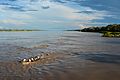
Amazon River near Iquitos, Peru
-
Meeting of Waters; the confluence of Rio Negro (blue) and Rio Solimões (sandy) near Manaus, Brazil
-
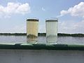
Water samples of the Solimões (left) and Rio Negro (right)
-
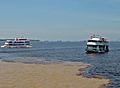
River taxi in Peru
-
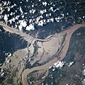
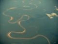
NASA satellite image of a flooded portion of the river
-
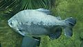
The tambaqui, an important species in Amazonian fisheries, breeds in the Amazon River
-
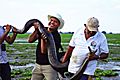
Green anaconda is the heaviest and one of the longest known extant snake species
-
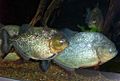
Characins, such as the piranha species, are prey for the giant otter, but these aggressive fish may also pose a danger to humans.
-
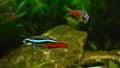
Neon tetra is one of the most popular aquarium fish
-
Solimões, the section of the upper Amazon River
-
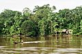
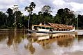
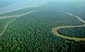
Aerial view of an Amazon tributary

_(14780994814).jpg)
.jpg)


.jpg)


.jpg)


_(8990193853).jpg)


See also
 In Spanish: Río Amazonas para niños
