
Bay of Plenty facts for kids
Quick facts for kids Bay of Plenty |
|
|---|---|

The Bay of Plenty seen from Whakatāne. The Whakatane River (foreground) is one of eight major rivers that empty into the bay.
|
|

Location of the bight in the North Island
|
|
| Country | New Zealand |
| Largest City | Tauranga |
| Basin features | |
| River system | Pacific Ocean |
| Tributaries |
|
|
Bay of Plenty
Te Moana-a-Toi (Māori)
|
|
|---|---|
|
Region
|
|
 |
|
| Country | New Zealand |
| Island | North Island |
| Seat | Whakatāne |
| Area | |
| • Total | 12,231 km2 (4,722 sq mi) |
| • Land | 12,072.00 km2 (4,661.03 sq mi) |
| Population
(June 2023)
|
|
| • Total | 354,100 |
| • Density | 28.951/km2 (74.983/sq mi) |
| Time zone | UTC+12 (NZST) |
| • Summer (DST) | UTC+13 (NZDT) |
| ISO 3166 code | NZ-BOP |
| HDI (2017) | 0.902 very high · 11th |
The Bay of Plenty (Māori: Te Moana-a-Toi) is a region of New Zealand, situated around a bight of the same name in the northern coast of the North Island. The bight stretches 260 km from the Coromandel Peninsula in the west to Cape Runaway in the east. The Bay of Plenty Region, governed by the Bay of Plenty Regional Council, incorporates several large islands in the bay, in addition to the mainland area. Called Te Moana-a-Toi (the Sea of Toi) in the Māori language after Toi, an early ancestor, the name 'Bay of Plenty' was bestowed by James Cook in 1769 when he noticed the abundant food supplies at several Māori villages there, in stark contrast to observations he had made earlier in Poverty Bay.
Contents
Economy
The subnational gross domestic product (GDP) of Bay of Plenty was estimated at NZ$17.24 billion in the year to March 2019, 5.7% of New Zealand's national GDP. The subnational GDP per capita was estimated at $53,700 in the same period. In the year to March 2018, primary industries contributed $1.89 billion (11.6%) to the regional GDP, goods-producing industries contributed $3.24 billion (20.0%), service industries contributed $9.72 billion (59.8%), and taxes and duties contributed $1.39 billion (8.6%).

Agriculture, natural resources and tourism are the major industries. Most (96 per cent) of the region is defined as 'rural', with 22% of land usage representing farm land and 38% representing nature reserve land. The most common agricultural land uses are horticulture, dairy, grazing and sheep farming. The region has over 11,500 hectares of horticultural land, predominantly producing kiwifruit and avocadoes. The region also has an abundance of coastal, forestry and geothermal resources. Forestry emerged as a vital industry in the 1950s, with radiata pine being planted during the early 20th century. Forestry is commercially planted and managed, mostly using planted foreign tree species, and timber is sent to the Port of Tauranga for export. Geothermal activity is a source of tourism, and geothermal energy is emerging as a major regional source of electricity. Tourism is the other notable industry, accounting for 15% of the region's GDP from March 2000 to 2004.
Overall economic growth in the Bay of Plenty averaged 2.1% between March 2000 and 2004, compared with the national rate of 3.5%, although per capita real GDP growth in the five years to March 2003 matched the national growth rate at an averaged 2.3%. In the 2013 Census, the median annual income was $26,200, below the national median of $28,500. Further, 39.3% of people aged 15 years or older earned an annual income of less than $20,000, compared with 38.2% of people nationally. Unemployment was at 9.0% of people 15 years or older, compared with 7.1% nationally.
Sport
The Bay of Plenty is represented in several domestic sporting competitions. The Bay of Plenty Rugby Union oversees the Bay of Plenty Steamers, who play in the Mitre10 Cup. The Steamers are also a feeder club for the Chiefs who play in the Super Rugby competition. The Waikato/Bay of Plenty Magic compete in the ANZ Championship in netball, having previously played in the National Bank Cup. Bay of Plenty also makes up a part of the Northern Districts cricket region and the Midlands hockey region.
Transport
The Bay of Plenty has 227 kilometres (141 mi) of rail network and 4,460 kilometres (2,770 mi) of roads. The main rail line in the region is the East Coast Main Trunk Railway, which extends from Hamilton in the Waikato region to Kawerau via Tauranga, with the Murupara Branch Railway extending the Kawerau terminus to Murupara, and the Mount Maunganui Branch connecting the Mount Maunganui terminus with the East Coast Main Trunk. Rail networks in the region are used exclusively for freight. The hub of regional economic activity is the Port of Tauranga, with well-established rail and road connections to other parts of the region. Three commercial airports also operate in the Bay of Plenty: Tauranga Airport, Rotorua Airport and Whakatane Airport.
Car travel remains the dominant form of transport in the region. In 2002, the number of vehicles owned in the region was 189,000, with an average of 1.51 vehicles per household. Public transport bus services exist only in Tauranga and Rotorua. Significant growth in the Western Bay of Plenty District has seen increased strain on road infrastructure, particularly with increasing traffic congestion in Tauranga. Due to this growth, a new highway network is being planned and constructed in Tauranga to join with its current network spanning on the western side of the city. The NZ Transport Agency, in conjunction with Environment Bay of Plenty, Tauranga City and the Western Bay of Plenty District Councils, is planning to build an Eastern Motorway bypassing Te Puke, a Western Motorway bypassing Omokoroa and a smaller Southern Motorway.
Images for kids
-
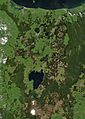
Satellite photo of the Bay of Plenty (top half of image)
-
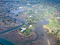
Bay of Plenty farmlands, 2014
-
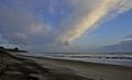
Pukehina Beach
-
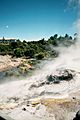
Geothermal activity at Whakarewarewa
-
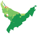
Population density map of the Bay of Plenty at the 2006 Census. Red = High, Green = Low.


