
Canyon Country, Santa Clarita, California facts for kids
Quick facts for kids
Canyon Country
|
|
|---|---|
|
Neighborhood of Santa Clarita
|
|

View of Kenroy Avenue, looking south towards Soledad Canyon Road, with the San Gabriel Mountains in the background.
|
|

Canyon Country, Santa Clarita, California
Location in Santa Clarita

Canyon Country, Santa Clarita, California
Location in the Los Angeles metropolitan area

Canyon Country, Santa Clarita, California
Location in California
|
|
| Country | |
| State | |
| County | Los Angeles |
| City | Santa Clarita |
| Elevation | 1,509 ft (460 m) |
| Time zone | UTC-8 (Pacific (PST)) |
| • Summer (DST) | UTC-7 (PDT) |
| ZIP Code |
91321, 91350, 91351, 91387, 91390
|
| Area code(s) | 661 |
| GNIS feature ID | 1946238 |
| Website | http://www.santa-clarita.com/ |
Canyon Country is a neighborhood in the eastern part of the city of Santa Clarita, in northwestern Los Angeles County, California, United States. It lies along the Santa Clara River between the Sierra Pelona Mountains and the San Gabriel Mountains. It is the most populous of Santa Clarita's four neighborhoods.
History
The area was the ancestral homeland of the Tataviam people for over five hundred years, and other tribes before then, such as the Tongva, Kitanemuk, and Serrano people. After the Spanish invasion, the valley first became grazing lands of the Mission San Fernando Rey de España around 1790. In 1834, after Mexican Independence, it became part of the Rancho San Francisco land grant centered on the confluence of the Santa Clara River and Castaic Creek.
In the 1880s the rancho become the Newhall Ranch empire of Henry Newhall, now the present day Newhall Land and Farming Company. In 1928 the St. Francis Dam collapsed, suddenly flooding and washing away settlements and people along the Santa Clara River section of present-day Santa Clarita not including Canyon Country. Canyon Country was originally to be called Solemint. It later absorbed the community to the west called Honby. In the 1960s and 1970s the Newhall Land company's suburban developments transformed Canyon Country and the surrounding towns into a focused residential and cultural city.
The house of The Crandall family used in the movie Don't Tell Mom the Babysitter's Dead is located in this town. The hit ABC shows Wipeout, Winter Wipeout, and Spring Wipeout are all filmed here.
The Canyon Country area was a mecca for show business personalities like Cliffe Stone of Home Town Jamboree, singer Gene Vincent, Hall of Fame Guitarist Bill Aken (aka Zane Ashton), actress Linda Gray, rock and roll legend Del Shannon, among others. The William S. Hart ranch was a well known tourist attraction along with Gene Autry's Melody Ranch.
Santa Clarita founding
In 1987, Canyon Country was one of four communities, with Valencia, Newhall, and Saugus, that merged to create the city of Santa Clarita, California. The latitude of Canyon Country is 34.423N and the longitude is -118.471W. Canyon Country has a population of 59,530 people.
Canyon Country is home to the Placerita Canyon Nature Center, which is also the site of California's original gold discovery at the historic "Oak of the Golden Dream" in 1842.
Services
The Los Angeles County Fire Department Station 104 (Quint) and Station 107 (Engine and Paramedic Squad) serve the community.
Demographics
As of 2019, the population of zip code 91351 was 32,711, and the population of 91387 was 42,034. The median household incomes in 91351 and 91387 were $81,758 and $98,371, respectively.
Education
Canyon Country elementary school students attend schools in Saugus Union School District and Sulphur Springs School District.
Middle and high school students in Canyon Country attend schools in William S. Hart Union High School District, in particular Sierra Vista and La Mesa Junior High Schools, and Canyon and Golden Valley High Schools.
Santa Clarita Christian School is located in Canyon Country. College of the Canyons has a satellite campus in Canyon Country in addition to its main campus in Valencia. Charter College has a campus in Canyon Country, one of three campuses in California (the others are in Lancaster and Oxnard).
Images for kids
-
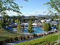
Santa Clarita Aquatics Center, part of the larger George A. Caravalho Sports Complex

See also
 In Spanish: Canyon Country (California) para niños
