
Caspian Sea facts for kids
Quick facts for kids Caspian Sea |
|
|---|---|
| Xəzər dənizi / دریای کاسپین / Каспий теңізі / Каспийское море / Hazar deňzi | |

The Caspian Sea as captured by the MODIS on the orbiting Terra satellite, June 2003
|
|
| Coordinates | 41°40′N 50°40′E / 41.667°N 50.667°E |
| Type | Endorheic, Saline, Permanent, Natural |
| Primary inflows | Volga River, Ural River, Kura River, Terek River |
| Primary outflows | Evaporation, Garabogazköl |
| Catchment area | 3,626,000 km2 (1,400,000 sq mi) |
| Basin countries | Azerbaijan, Iran, Kazakhstan, Russia, Turkmenistan |
| Max. length | 1,030 km (640 mi) |
| Max. width | 435 km (270 mi) |
| Surface area | 371,000 km2 (143,200 sq mi) |
| Average depth | 211 m (690 ft) |
| Max. depth | 1,025 m (3,360 ft) |
| Water volume | 78,200 km3 (18,800 cu mi) |
| Residence time | 250 years |
| Shore length1 | 7,000 km (4,300 mi) |
| Surface elevation | −28 m (−92 ft) |
| Islands | 26+ |
| Settlements | Baku (Azerbaijan), Anzali (Iran), Aktau (Kazakhstan), Makhachkala (Russia), Türkmenbaşy (Turkmenistan) (see article) |
| 1 Shore length is not a well-defined measure. | |

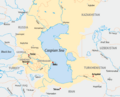
The Caspian Sea is the largest enclosed inland body of water on Earth by area, variously classed as the world's largest lake or a full-fledged sea. It is in an endorheic basin (a basin without outflows) located between Europe and Asia. It is bounded by Kazakhstan to the northeast, Russia to the northwest, Azerbaijan to the west, Iran to the south, and Turkmenistan to the southeast.
The Caspian Sea presently lies about 28 m (92 ft) below sea level in the Caspian Depression, to the east of the Caucasus Mountains and to the west of the vast steppe of Central Asia. The sea bed in the southern part reaches as low as 1023 m below sea level, which is the second lowest natural depression on earth after Lake Baikal (-1180 m). The ancient inhabitants of its coast perceived the Caspian Sea as an ocean, probably because of its saltiness and large size.
The sea has a surface area of 371,000 km2 (143,200 sq mi) (not including the detached lagoon of Garabogazköl) and a volume of 78,200 km3 (18,800 cu mi). It has a salinity of approximately 1.2% (12 g/l), about a third of the salinity of most seawater.
Contents
Physical characteristics
Formation
The Caspian Sea, like the Black Sea, Namak Lake, and Lake Urmia, is a remnant of the ancient Paratethys Sea. It became landlocked about 5.5 million years ago due to tectonic uplift and a fall in sea level. During warm and dry climatic periods, the landlocked sea almost dried up, depositing evaporitic sediments like halite that were covered by wind-blown deposits and were sealed off as an evaporite sink when cool, wet climates refilled the basin. (Comparable evaporite beds underlie the Mediterranean.) Due to the current inflow of fresh water, the Caspian Sea is a freshwater lake in its northern portions, and is most saline on the Iranian shore, where the catchment basin contributes little flow. Currently, the mean salinity of the Caspian is one third that of Earth's oceans. The Garabogazköl embayment, which dried up when water flow from the main body of the Caspian was blocked in the 1980s but has since been restored, routinely exceeds oceanic salinity by a factor of 10.
Geography

The Caspian Sea is the largest inland body of water in the world and accounts for 40 to 44% of the total lacustrine waters of the world. The coastlines of the Caspian are shared by Azerbaijan, Iran, Kazakhstan, Russia, and Turkmenistan. The Caspian is divided into three distinct physical regions: the Northern, Middle, and Southern Caspian. The Northern–Middle boundary is the Mangyshlak Threshold, which runs through Chechen Island and Cape Tiub-Karagan. The Middle–Southern boundary is the Apsheron Threshold, a sill of tectonic origin between the Eurasian continent and an oceanic remnant, that runs through Zhiloi Island and Cape Kuuli. The Garabogazköl Bay is the saline eastern inlet of the Caspian, which is part of Turkmenistan and at times has been a lake in its own right due to the isthmus that cuts it off from the Caspian.
Differences between the three regions are dramatic. The Northern Caspian only includes the Caspian shelf, and is very shallow; it accounts for less than 1% of the total water volume with an average depth of only 5–6 metres (16–20 ft). The sea noticeably drops off towards the Middle Caspian, where the average depth is 190 metres (620 ft). The Southern Caspian is the deepest, with oceanic depths of over 1,000 metres (3,300 ft), greatly exceeding the depth of other regional seas, such as the Persian Gulf. The Middle and Southern Caspian account for 33% and 66% of the total water volume, respectively. The northern portion of the Caspian Sea typically freezes in the winter, and in the coldest winters ice forms in the south as well.
Over 130 rivers provide inflow to the Caspian, with the Volga River being the largest. A second affluent, the Ural River, flows in from the north, and the Kura River flows into the sea from the west. In the past, the Amu Darya (Oxus) of Central Asia in the east often changed course to empty into the Caspian through a now-desiccated riverbed called the Uzboy River, as did the Syr Darya farther north. The Caspian also has several small islands; they are primarily located in the north and have a collective land area of roughly 2,000 km2 (770 sq mi). Adjacent to the North Caspian is the Caspian Depression, a low-lying region 27 metres (89 ft) below sea level. The Central Asian steppes stretch across the northeast coast, while the Caucasus mountains hug the western shore. The biomes to both the north and east are characterized by cold, continental deserts. Conversely, the climate to the southwest and south are generally warm with uneven elevation due to a mix of highlands and mountain ranges; the drastic changes in climate alongside the Caspian have led to a great deal of biodiversity in the region.
The Caspian Sea has numerous islands throughout, all of them near the coasts; none in the deeper parts of the sea. Ogurja Ada is the largest island. The island is 37 km (23 mi) long, with gazelles roaming freely on it. In the North Caspian, the majority of the islands are small and uninhabited, like the Tyuleniy Archipelago, an Important Bird Area (IBA), although some of them have human settlements.
Hydrology

The Caspian has characteristics common to both seas and lakes. It is often listed as the world's largest lake, although it is not a freshwater lake. It contains about 3.5 times more water, by volume, than all five of North America's Great Lakes combined. The Caspian was once part of the Tethys Ocean, but became landlocked about 5.5 million years ago due to plate tectonics. The Volga River (about 80% of the inflow) and the Ural River discharge into the Caspian Sea, but it has no natural outflow other than by evaporation. Thus the Caspian ecosystem is a closed basin, with its own sea level history that is independent of the eustatic level of the world's oceans.
The level of the Caspian has fallen and risen, often rapidly, many times over the centuries. Some Russian historians claim that a medieval rising of the Caspian, perhaps caused by the Amu Darya changing its inflow to the Caspian from the 13th century to the 16th century, caused the coastal towns of Khazaria, such as Atil, to flood. In 2004, the water level was 28 metres (92 feet) below sea level.
Over the centuries, Caspian Sea levels have changed in synchrony with the estimated discharge of the Volga, which in turn depends on rainfall levels in its vast catchment basin. Precipitation is related to variations in the amount of North Atlantic depressions that reach the interior, and they in turn are affected by cycles of the North Atlantic Oscillation. Thus levels in the Caspian Sea relate to atmospheric conditions in the North Atlantic thousands of miles to the northwest.
The last short-term sea-level cycle started with a sea-level fall of 3 m (10 ft) from 1929 to 1977, followed by a rise of 3 m (10 ft) from 1977 until 1995. Since then smaller oscillations have taken place.
Environmental degradation
The Volga River, the largest in Europe, drains 20% of the European land area and is the source of 80% of the Caspian's inflow. Its lower reaches are heavily developed with numerous unregulated releases of chemical and biological pollutants. Although existing data are sparse and of questionable quality, there is ample evidence to suggest that the Volga is one of the principal sources of transboundary contaminants into the Caspian.
The magnitude of fossil fuel extraction and transport activity in the Caspian also poses a risk to the environment. The island of Vulf off Baku, for example, has suffered ecological damage as a result of the petrochemical industry; this has significantly decreased the number of species of marine birds in the area. Existing and planned oil and gas pipelines under the sea further increase the potential threat to the environment.
The Vladimir Filanovsky field in the Russian section of the body of water was discovered for its wealth of oil in 2005. It is reportedly the largest discovery of oil that they have had in 25 years. It was announced in October 2016 that Lukoil would start production in this region.
Nature
_4.jpg)
Flora
The rising level of the Caspian Sea between 1994–96 reduced the number of habitats for rare species of aquatic vegetation. This has been attributed to a general lack of seeding material in newly formed coastal lagoons and water bodies.
Fauna

The Caspian turtle (Mauremys caspica), although found in neighboring areas, is a wholly freshwater species. The zebra mussel is native to the Caspian and Black Sea basins, but has become an invasive species elsewhere, when introduced. The area has given its name to several species, including the Caspian gull and the Caspian tern. The Caspian seal (Pusa caspica) is the only aquatic mammal and is endemic to the Caspian Sea, being one of very few seal species that live in inland waters, but is different from those inhabiting freshwaters due to the hydrological environment of the sea.
Archeological studies of Gobustan petroglyphs indicate that there once had been dolphins and porpoises, or a certain species of beaked whales and a whaling scene indicates of large baleen whales likely being present in Caspian Sea at least until when Caspian Sea was a part of ocean system or until Quaternary or much more recent periods such as until the last glacial period or antiquity. Although the rock art on Kichikdash Mountain assumed to be of a dolphin or of a beaked whale, might instead represent the famous beluga sturgeon due to its size (430 cm in length), but fossil records suggest certain ancestors of modern dolphins and whales, such as Macrokentriodon morani (bottlenose dolphins) and Balaenoptera sibbaldina (blue whales) were presumably larger than their present descendants. From the same artworks, auks, like Brunnich's Guillemot could also have been in the sea as well, and the existences of current endemic, oceanic species such as lagoon cockles which was genetically identified to originate in Caspian/Black Seas regions, and these petroglyphs suggest marine inflow between the current Caspian Sea and the Arctic Ocean or North Sea, or the Black Sea.
The sea's basin (including associated waters such as rivers) has 160 native species and subspecies of fish in more than 60 genera. About 62% of the species and subspecies are endemic, as are 4–6 genera (depending on taxonomic treatment). The lake proper has 115 natives, including 73 endemics (63.5%). Among the more than 50 genera in the lake proper, 3–4 are endemic: Anatirostrum, Caspiomyzon, Chasar (often included in Ponticola) and Hyrcanogobius. By far the most numerous families in the lake proper are gobies (35 species and subspecies), cyprinids (32) and clupeids (22). Two particularly rich genera are Alosa with 18 endemic species/subspecies and Benthophilus with 16 endemic species. Other examples of endemics are four species of Clupeonella, Gobio volgensis, two Rutilus, three Sabanejewia, Stenodus leucichthys, two Salmo, two Mesogobius and three Neogobius. Most non-endemic natives are either shared with the Black Sea basin or widespread Palearctic species such as crucian carp, Prussian carp, common carp, common bream, common bleak, asp, white bream, sunbleak, common dace, common roach, common rudd, European chub, sichel, tench, European weatherfish, wels catfish, northern pike, burbot, European perch and zander. Almost 30 non-indigenous, introduced fish species have been reported from the Caspian Sea, but only a few have become established.
Six sturgeon species, the Russian, bastard, Persian, sterlet, starry and beluga, are native to the Caspian Sea. The last of these is arguably the largest freshwater fish in the world. The sturgeon yield roe (eggs) that are processed into caviar. Overfishing has depleted a number of the historic fisheries. In recent years, overfishing has threatened the sturgeon population to the point that environmentalists advocate banning sturgeon fishing completely until the population recovers. The high price of sturgeon caviar, however, allows fishermen to afford bribes to ensure the authorities look the other way, making regulations in many locations ineffective. Caviar harvesting further endangers the fish stocks, since it targets reproductive females.
Terrestrial
Flora
Many rare and endemic plant species of Russia are associated with the tidal areas of the Volga delta and riparian forests of the Samur River delta. The shoreline is also a unique refuge for plants adapted to the loose sands of the Central Asian Deserts. The principal limiting factors to successful establishment of plant species are hydrological imbalances within the surrounding deltas, water pollution, and various land reclamation activities. The water level change within the Caspian Sea is an indirect reason for which plants may not get established.
These affect aquatic plants of the Volga Delta, such as Aldrovanda vesiculosa and the native Nelumbo caspica. About 11 plant species are found in the Samur River Delta, including the unique liana forests that date back to the Tertiary period.
History

_Empire_1747.JPG)

The earliest hominid remains found around the Caspian Sea are from Dmanisi dating back to around 1.8 Ma and yielded a number of skeletal remains of Homo erectus or Homo ergaster. More later evidence for human occupation of the region come from a number of caves in Georgia and Azerbaijan such as Kudaro and Azykh Caves. There is evidence for Lower Palaeolithic human occupation south of the Caspian from western Alburz. These are Ganj Par and Darband Cave sites.
Neanderthal remains also have been discovered at a cave site in Georgia. Discoveries in the Huto cave and the adjacent Kamarband cave, near the town of Behshahr, Mazandaran south of the Caspian in Iran, suggest human habitation of the area as early as 11,000 years ago.
The Caspian area is rich in energy resources. Oil wells were being dug in the region as early as the 10th century to reach oil "for use in everyday life, both for medicinal purposes and for heating and lighting in homes." By the 16th century, Europeans were aware of the rich oil and gas deposits around the area. English traders Thomas Bannister and Jeffrey Duckett described the area around Baku as "a strange thing to behold, for there issueth out of the ground a marvelous quantity of oil, which serveth all the country to burn in their houses. This oil is black and is called nefte. There is also by the town of Baku, another kind of oil which is white and very precious (i.e., petroleum)."
In the 18th century, during the rule of Peter I the Great, Fedor I. Soimonov, hydrographer and pioneering explorer of the Caspian Sea charted the until then little known body of water. Soimonov drew a set of four maps and wrote the 'Pilot of the Caspian Sea', the first report and modern maps of the Caspian, that were published in 1720 by the Russian Academy of Sciences.
Today, oil and gas platforms are abounding along the edges of the sea.
Oil extraction


The world's first offshore wells and machine-drilled wells were made in Bibi-Heybat Bay, near Baku, Azerbaijan. In 1873, exploration and development of oil began in some of the largest fields known to exist in the world at that time on the Absheron peninsula near the villages of Balakhanli, Sabunchi, Ramana and Bibi Heybat. Total recoverable reserves were more than 500 million tons. By 1900, Baku had more than 3,000 oil wells, 2,000 of which were producing at industrial levels. By the end of the 19th century, Baku became known as the "black gold capital", and many skilled workers and specialists flocked to the city.
By the beginning of the 20th century, Baku was the centre of international oil industry. In 1920, when the Bolsheviks captured Azerbaijan, all private property – including oil wells and factories – was confiscated. Afterwards, the republic's entire oil industry came under the control of the Soviet Union. By 1941, Azerbaijan was producing a record 23.5 million tons of oil, and the Baku region supplied nearly 72% of all oil extracted in the entire USSR.
In 1994, the "Contract of the Century" was signed, signalling the start of major international development of the Baku oil fields. The Baku–Tbilisi–Ceyhan pipeline, a major pipeline allowing Azerbaijan oil to flow straight to the Turkish Mediterranean port of Ceyhan, opened in 2006.
Images for kids
-
Area around the Caspian Sea. Yellow area indicates the (approximate) drainage area.
-

Most tadpole gobies (Benthophilus) are only found in the Caspian Sea basin.
-

Illustration of two Caspian tigers, extinct in the region since the 1970s.
-
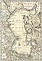
A New and Accurate Map of the Caspian Sea by the Soskam Sabbus & Emanuel Bowen, 1747.
-

Baku, the capital of Azerbaijan is the largest city by the Caspian Sea.
-

Makhachkala, the capital of the Russian republic of Dagestan, is the third-largest city on the Caspian Sea.
-
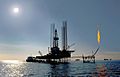
Drilling platform "Iran Khazar" in use at a Dragon Oil production platform in the Cheleken field (Turkmenistan).
-
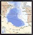
Southern Caspian Energy Prospects (portion of Iran). Country Profile 2004.
-
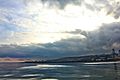
Caspian Sea, Azerbaijan


.jpg)


See also
 In Spanish: Mar Caspio para niños
