
Entrada Sandstone facts for kids
Quick facts for kids Entrada SandstoneStratigraphic range: Middle Jurassic |
|
|---|---|

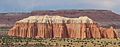
Type of the Entrada Formation at Entrada Point, Emery County, Utah
|
|
| Type | Geological formation |
| Sub-units | Cannonville Member, Cow Springs Member, Dewey Bridge Member, Escalante Member, Henrieville Member, EExeter Member, Gunsight Butte Member, Iyanbito Member, Moab Member, Red Mesa Member, Slick Rock Member |
| Underlies | Curtis Formation |
| Overlies | Carmel Formation |
| Lithology | |
| Primary | fluvial mudstone, siltstone, and eolian sandstone |
| Location | |
| Coordinates | 39°15′40″N 110°32′35″W / 39.261°N 110.543°W |
| Region | Colorado Plateau |
| Country | United States |
| Type section | |
| Named for | Entrada Point, northern San Rafael Swell |
| Named by | James Gilluly and J.B. Reeside, Jr. (1928) |

The Entrada Sandstone is a formation in the San Rafael Group found in the U.S. states of Wyoming, Colorado, northwest New Mexico, northeast Arizona, and southeast Utah. Part of the Colorado Plateau, this formation was deposited during the Jurassic period sometime between 180 and 140 million years ago in various environments, including tidal mudflats, beaches, and sand dunes. The Middle Jurassic San Rafael Group was dominantly deposited as ergs (sand seas) in a desert environment around the shallow Sundance Sea.
Age and history of investigation
This formation has been dated to the early to middle Callovian stage of the latest Middle Jurassic. The type locality and place for which the unit is named is Entrada Point, located in the northern part the San Rafael Swell in Emery County, Utah.
The Entrada Sandstone was named as one of the four formations of the San Rafael Group by James Gilluly and Reeside in 1928. In the 1928 description, the Entrada is overlain by the Curtis Formation, and overlies the Carmel Formation. In the Curtis Mountains region of northeastern Arizona, the Entrada is overlain by the Wanakah Formation. Gregory and Moore worked out the geographic extent of the formation and gave an overview of it in 1931. The extent was revised several times afterwards (most recently in 1992 by Condon). It was divided into the Gunsight Butte, Cannonville, and Escalante members by Thompson and Stokes in 1970. The principal reference for the formation was written in 1988 by Peterson.
-
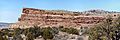
Entrada Sandstone overlain by Curtis Formation in Capitol Reef National Park's Cathedral Valley
-
Entrada Formation at Curtis Point, Emery County, Utah.
Members
Entrada members are (in alphabetical order):
- Cannonville Member (UT),
- Cow Springs Member (AZ),
- Dewey Bridge Member (CO, UT) - named after the type locality at Dewey Bridge. This brick-red layer has a blocky look to it.
- Escalante Member (UT),
- Henrieville Member (UT),
- Exeter Member (NM),
- Gunsight Butte Member (UT),
- Iyanbito Member (NM),
- Moab Member (CO, UT) or Moab Tongue (CO, UT) - named after the type locality of Moab, Utah. The whitish sands from inland dunes make up this "cap rock" layer, as seen atop Delicate Arch and Broken Arch in Arches National Park.
- Red Mesa Member (AZ, NM, UT),
- Slick Rock Member (CO, UT) - named for the type locality at Slick Rock, Colorado; rounded beach sands were cemented together to create this uniform layer.
Places found

Entrada Sandstone is found in these geologic locations:
Geologic province:
- Anadarko Basin
- Black Mesa Basin
- Denver Basin
- Great Basin province
- Green River Basin
- Las Vegas-Raton Basin
- Paradox Basin
- Piceance Basin
- Plateau sedimentary province
- San Juan Basin
- Sierra Grande Uplift

Found in these parklands (incomplete list):
- Arches National Park
- Capitol Reef National Park
- Goblin Valley State Park
- Kodachrome Basin State Park
Spatial distribution:
