
Geography of Sydney facts for kids


The geography of Sydney is characterised by its coastal location on a basin bordered by the Pacific Ocean to the east, the Blue Mountains to the west, the Hawkesbury River to the north and the Woronora Plateau to the south. Sydney lies on a submergent coastline on the east coast of New South Wales, where the ocean level has risen to flood deep river valleys (rias) carved in the Sydney sandstone. Port Jackson, better known as Sydney Harbour, is one such ria.
The Sydney area lies on Triassic shales and sandstones. The region mostly consists of low rolling hills and wide valleys in a rain shadow area that is shielded by the Great Dividing Range. Sydney sprawls over two major regions: the Cumberland Plain, a relatively flat region lying to the west of Sydney Harbour, and the Hornsby Plateau, a plateau north of the Harbour rising to 200 metres and dissected by steep valleys. Sydney's native plant species are predominantly eucalyptus trees, and its soils are usually red and yellow in texture. The endemic flora is home to a variety of bird, insect, reptile and mammal species, which are conspicuous in urban areas.
There are more than 70 harbour and ocean beaches in the urban area. Most of Sydney's water storages are on tributaries of the Nepean River. Parramatta River drains a large area of Sydney's western suburbs. With 5,005,400 inhabitants (as of 2016) and an urban population density of 2037 people per square kilometre, Sydney's urban area covers 1,788 km2 (690 sq mi), comprising 35% of Sydney and is constantly growing.
Greater Sydney's boundaries stretch 88 kilometres (55 mi) from Palm Beach in the north to Waterfall in the south, and 70 kilometres (43 mi) from Bondi Beach in the east to Emu Plains in the west.
Contents
Physical geography
Geology
.jpg)


Sydney sprawls over two major regions: the Cumberland Plain, a relatively flat region lying to the south and west of Port Jackson, and the Hornsby Plateau, a sandstone plateau lying mainly to the north of the harbour, rising to 200 metres above sea level within the urban area and dissected by steep valleys such as the Lane Cove River valley. Erosion by coastal streams has created a landscape of deep canyons and remnant plateaus.
The rising sea level between 18,000 and 6,000 years ago flooded the rias to form estuaries and deep harbours. The city has fault lines which run considerably deep beneath the Sydney basin, dating back to when New Zealand started breaking away from Australia more than 85 million years ago. To the east the basin continues to the edge of the continental shelf. The centre of the basin is located around 30 kilometres (19 mi) west of the Sydney central business district at Fairfield.
Sydney sandstone, being very porous, has shale lenses and fossil riverbeds dotted throughout and it is some 200 metres (656 feet) thick. The sandstone was probably deposited in a freshwater delta and is the caprock which controls the erosion and scarp retreat of the Illawarra escarpment. Six kilometres of sandstone and shale lie under Sydney. Bringelly Shale and Minchinbury Sandstone are often seen in the greater western parts of Sydney. Ashfield Shale is observed in the inner western suburbs. These components are part of the Wianamatta Shale group. Mittagong Formation sighted in a few areas in northern Sydney.
In the Sydney sandstone, the ripple marks from the ancient river that brought the grains of sand are distinctive and easily seen, telling geologists that the sand comes from rocks formed between 500 to 700 million years ago far to the south. This means that the highest part of the visible lines almost always faces approximately south. There are volcanic rocks from low hills in the shale landscapes. The Basin's sedimentary rocks have been subject to uplift with gentle folding and minor faulting during the formation of the Great Dividing Range.
At a time in the past, monocline formed to the west of Sydney. The monocline is a sloping bend that raises the sandstone well above where it is expected to be seen, and this is why the whole of the visible top of the Blue Mountains is made of sandstone. Sandstone slopes in the Sydney area are on three sides: to the west the Blue Mountains, and to the north and south, the Hornsby and Woronora plateaux'.
The Cumberland Plain is a low-lying area (largely over shale and labile sandstone) which derives its recognition largely by comparison with the surrounding uplands of harder quartzose, the Hawkesbury Sandstone. Relative to the surrounding higher sandstone lands (Hornsby and Blue Mountains Plateaux) it was an early matter of debate in Sydney physiographic circles as to whether the Cumberland Plain had gone down, or the surrounding plateaux had been raised up.
Prospect Hill in western Sydney is the largest assemblage of igneous rock in Sydney. The oval-shaped ridge was made many millions of years ago when volcanic material from the Earth's core actuated upwards and then sideways. Slow erosion of the overlying layers of sedimentary rock by the flow of rainwater have eventually laid bare the edges of the volcanic and metamorphic rocks of the intrusion. The Gap, an ocean cliff on the South Head peninsula in Watsons Bay, was laid as sediment more than 200 million years ago in the Triassic period. During the Jurassic era, a cataclysmic event resulted in an enormous crack forming within the strata. The Gap itself forms a sequence that continues offshore to the edge of the Sahul Shelf.
Rivers
.png)

The Nepean River rises to the south in the Woronora Plateau, and wraps around the western edge of the city. Swamps and lagoons are existent on the floodplain of the Nepean River. Where the Nepean turns east it becomes the Hawkesbury River, which winds through the Hornsby Plateau before emptying into Broken Bay. Broken Bay and the lower Hawkesbury form the commonly accepted boundary between Sydney and the Central Coast to the north. The remaining section of Warragamba River flows 3.5 kilometres (2.2 mi) north-east from the Warragamba Dam spillway to its confluence with the Nepean River.
Parramatta River's headwaters are several local creeks including Toongabbie Creek and Hunts Creek, part of the upper Parramatta river catchment area. Hunt's creek flows from Lake Parramatta, a few kilometers North of Parramatta. At east Parramatta the river becomes a tidal estuary that flows into Port Jackson, commonly known as Sydney harbor. The reestablishment of foreshore mangroves has been a major focus of the ecological management of the Parramatta river and Sydney Harbor. Other major tributaries flow into Port Jackson from the North Shore and are the Lane Cove River and Middle Harbour Creek.
The south and southwest of Sydney is drained by the Georges River, flowing north from it's source near Appin, towards Liverpool and then turning east towards Botany Bay. The other major tributary of Botany Bay is the Cooks River, running through the inner-south western suburbs of Canterbury and Tempe. The Georges River estuary separates the main part of Sydney's urban area from the Sutherland Shire. The Woronora River, on the southern edge of the Sydney Plain, flows in a steep-sided valley from the Woronora Dam to the eastern estuary of the Georges River. The Hacking River is further south and runs through The Royal National Park into Port Hacking which forms the southern boundary of the Sutherland Shire.
Minor waterways draining Sydney's western suburbs include South Creek and Eastern Creek, flowing into the Hawkesbury, and Prospect Creek draining into the Georges River. Cowan Creek and Berowra Creek run north from the Upper North Shore to the Hawkesbury river. Sydney has a number islands in its harbour and surrounding rivers. Such islands include, Shark Island, Cockatoo Island, Clark Island, Snapper Island, Spectacle Island and Goat Island in Port Jackson. Bare Island in Botany Bay. Lion Island, Long Island and Milson Island in Hawkesbury River. Scotland Island in the Northern Beaches. And Rodd Island in Parramatta River.
Vegetation


In 1820s, the plain west of Parramatta and Liverpool was described as "a fine timbered country, perfectly clear of bush, through which you might, generally speaking, drive a gig in all directions, without any impediment in the shape of rocks, scrubs, or close forest". This confirmed earlier accounts by Governor Phillip, who suggested that the trees were "growing at a distance of some twenty to forty feet from each other, and in general entirely free from brushwood..."
The plant communities in the Sydney region are sclerophyll forests, which consist of wet and dry forests, thus making the city have two distinct biomes. Dry sclerophyll forests are the most predominant plants in the region. They contain eucalyptus trees which are usually in open woodlands, dry shrubs and a sparse grass in the understory. Bushfires play a critical role in revitalization of dry sclerophyll forests. Wet sclerophyll forests are found in the hilly areas in the Northern Suburbs, Forest District, North Shore and in the Blue Mountains, which are cooler and wetter than other areas in the Sydney region. They have narrow, relatively tall, dense trees with a lush, moist understorey of fleecy shrubs and tree ferns. Plant species within the wet sclerophyll zone include blue gum, karrabina, peppermints and eucalyptus oreades.
The most widespread eucalyptus species in the Sydney region include, Angophora costata (Sydney red gum), Eucalyptus piperita (Sydney peppermint), Eucalyptus sieberi (Silvertop Ash), Eucalyptus oblonga (stringybark), Eucalyptus capitellata (Brown Stringybark), Corymbia gummifera (red bloodwood), Eucalyptus racemosa (scribbly gum) and Eucalyptus haemastoma (scribbly gum). Non-eucalyptus species include, Tristaniopsis laurina (water gum) and Syncarpia glomulifera (turpentine tree). Most common shrub species include, but are not limited to, Banksia serrata, Ceratopetalum gummiferum, Banksia spinulosa and Xanthosia pilosa.
Sclerophyll forests developed as a result of the extreme age of the continent combined with Aboriginal fire use. Deep weathering of the crust leached chemicals out of the rock, leaving Australian soils deficient in nutrients. The sandstone is the basis of the nutrient-poor soils found in Sydney that developed over millennia and 'came to nurture a brilliant and immensely diverse array of plants'. As plants cannot afford to lose leaves to herbivores when nutrients are scarce, they defend their foliage with toxins. In eucalypts, these toxins give the bush its distinctive smell.
The Sydney Turpentine-Ironbark Forest, one of six main indigenous forest communities of Sydney, is a dry sclerophyll forest that contains trees around 20–30 metres tall, with ground cover composed of flowering shrubs and native grasses. This type of forest prefers a fertile clay soil derived from shale, with undulating hills and moderate rainfall. Its range does not extend to high-rainfall ridges. The Blue Gum High Forest, strictly found in northern parts of Sydney, is a a wet sclerophyll forest where the annual rainfall is over 1100 mm (43 in). It has trees between 20 and 40 metres tall. 180 species of indigenous plants have been identified at Dalrymple-Hay Nature Reserve.
Topography
.jpg)
At the time of European settlement, the Cumberland Plain contained 1,070 km² of woodlands and forests. The westward expansion of Sydney over the plain has placed enormous pressure on the woodlands and other local ecological communities, only 13% of which remain uncleared. Cleared and used first for agriculture and then for urban development, most of the ecological communities that originally flourished on the plain are now considered endangered. The Cumberland Plains has an area of roughly 2750 km2.
The oldest parts of the city are located in the flat areas south of the harbour; the North Shore was slower to develop because of its hilly topography, and was mostly a quiet backwater until the Sydney Harbour Bridge was opened in 1932, linking it to the rest of the city, with the suburbs surrounding the northern entrance to said bridge effectively developing North Sydney into a second Central Business District.
The extensive area covered by urban Sydney is formally divided into more than 300 suburbs for addressing and postal purposes, and administered as 38 local government areas. The City of Sydney itself covers a fairly small area comprising the central business district and its neighbouring inner-city suburbs. Sydney's central business district (CBD) extends southwards for about 2 kilometres (1.25 mi) from Sydney Cove, the point of the first European settlement. The west side is bounded by Darling Harbour, a popular tourist and nightlife precinct while Central station marks the southern end of the CBD. George Street serves as the Sydney CBD's main north-south thoroughfare.
_04.jpg)
The Northern Suburbs of Sydney are characterised by pristine waterways with immense greenery and large plots of manicured land. The region is home to many parks and reserves, the largest being Pennant Hills Park. Most of the North Shore suburbs are part of the Hawkesbury Plateau, a large sandstone plateau overlaid by a system of hilly ridges and gullies. Major waterways in the region include the Parramatta River, Lane Cove River and the many creek systems that branch out from these. The Lane Cove National Park and the Garigal National Park include many areas of remnant bushland adjacent to the Lane Cove River and Middle Harbour.
The Hills District, situated halfway between the northern suburbs and greater western Sydney, is a region so named for its characteristically comparatively hilly topography, akin to the Northern Suburbs and North Shore. Several of its suburbs have the word 'Hills' in their names. As the name indicates, the Hills District is an area of high elevation above sea level and thus creates orographic rainfall brought in by onshore winds from the Pacific Ocean.
The western suburbs lie on the relatively flat, lowly elevated parts of the Cumberland Plain. They are situated on a rain shadow, thanks to the Hills District to the northeast. Thus, they would tend to be drier than the coast and less lusher than the hilly Northern Suburbs. Despite being on the flatter areas, there are a few hilly or relatively elevated regions on the plain. Western Sydney Parklands, for instance, lies on a prominent ridge that is between 130 to 140 metres (430 to 460 ft) high. Some suburbs in the west situated on hilly ridges include Leppington and Oran Park to the southwest, Pemulwuy (Prospect Hill), Cecil Hills and Horsley Park to the greater west, and Greystanes, Seven Hills and Mount Druitt to the northwest.
Parks

The Sydney CBD contains prominent parks such as, Hyde Park, The Domain and Royal Botanic Gardens and Farm Cove on the harbour. Other parks in that vicinity include Wynyard and Hyde Park. The Royal Botanic Gardens is the most important green space in the Sydney region, hosting both scientific and leisure activities. There are 15 separate parks under the administration of the City of Sydney.
The inner west suburbs include Centennial Park and Moore Park in the east, Sydney Park and Royal National Park in the south, Ku-ring-gai Chase National Park in the north, and Western Sydney Parklands in the west. Other major parks in the Sydney metropolitan area include Auburn Botanical Gardens, Central Gardens Nature Reserve, Heathcote National Park, Georges River National Park, Lane Cove National Park and Blue Mountains National Park. There are large parks and reserves surrounding prominent bodies of water, such as those around Prospect Reservoir, Chipping Norton Lake and Lake Parramatta.
The Royal National Park was proclaimed on 26 April 1879 and with 13,200 hectares (51 square miles) is the second oldest national park in the world. The largest park in the Sydney metropolitan region is Ku-ring-gai Chase National Park, established in 1894 with an area of 15,400 hectares (59 square miles). It is regarded for its well-preserved records of indigenous habitation and more than 800 rock engravings, cave drawings, and middens have been located in the park. The Domain is the oldest public parkland in Australia and measures 16.2 hectares (0.1 square miles) in area. Its location was used for both relaxation and the grazing of animals from the earliest days of the colony.
Agriculture
_Airport_site_-_Anton_Rd.JPG)
The outskirts of Greater Western Sydney mainly consist of sparsely populated, but vast, rural meadows with undulating hills and scenic vistas. The western suburbs of Mount Vernon, Kemps Creek, Orchard Hills, Luddenham, Mulgoa, Bringelly, Silverdale and Horsley Park, among others, lie in a countryside. Furthermore, Abbotsbury, Cecil Hills and Glenmore Park were farms through until the 1980s when it was decided to redevelop them for housing. The area around the site of Regentville has remained largely rural, if hemmed in somewhat by the modern residential suburbs of Jamisontown and Glenmore Park.
In the 1800s, John Blaxland built an original wooden weir at "Grove Farm" (now known as Wallacia) for a sandstone flour mill and additional brewery. The land was also used for wheat farming until 1861 when wheat rust infected the entire crop. The rural regions were chiefly one of dairying and grazing during the 19th century, but in the early 20th century - because of its rural atmosphere and proximity to Sydney - tourism developed as people opened their homes as guest houses. Today, the rural areas include a number of orchards and vineyards. Vegetable farming and fruit picking are common activities.
Regions

There are a number of informal regional names describing large sections of the urban area. Not all suburbs are necessarily covered by any of the following informal regional categories.
The regions are Canterbury-Bankstown, the Eastern Suburbs, the Forest District, Greater Western Sydney, the Hills District, the Inner West, the Macarthur region, the Northern Beaches, the Northern Suburbs, the North Shore, Southern Sydney, South-western Sydney, the St George district, the Sutherland Shire and Western Sydney. The Blue Mountains are at times considered to be part of Sydney's metropolitan area.
The largest commercial centres outside of the CBD are North Sydney and Chatswood in the north, Parramatta to the west, Liverpool in the south-west, Hurstville in the south, and Bondi Junction to the east. There has been accelerating commercial development in Parramatta since the 1950s as firms serving Western Sydney have set up regional offices and recognised the region's significant residential population mass and cheaper rents.
Climate

Sydney has a humid subtropical climate (Cfa) with warm, sometimes hot summers, and winters shifting from mild to cool. Although Sydney is predominantly humid subtropical, the hilly wet areas in the North Shore, Northern Suburbs, Forest District and Hills District have an oceanic climate (Cfb). The weather is moderated by proximity to the ocean, and more extreme temperatures are recorded in the inland western suburbs.
The warmest month in the CBD is January, with an average air temperature range at Observatory Hill of 19.6–26.5 °C (67.3–79.7 °F). The coldest month is July, with an average range of 8.7–17.4 °C (47.7–63.3 °F). In the west, the temperatures average between 17.5–28.4 °C (63.5–83.1 °F) in summer. In winter, they're normally between 6.2–17.4 °C (43.2–63.3 °F). In late spring and summer, Sydney can sometimes get northwesterly winds from the Outback, which are dry and hot, making the temperatures reach above 40 °C (104.0 °F). Frost is oftentimes observed in the outer suburbs.
Rainfall is spread throughout the year, but is slightly higher during the first half of the year when easterly winds dominate. Sydney's coast generally receives around 1,000 mm (39.37 in) to 1,200 mm (47.24 in) of rain annually. The western suburbs receive around 800 mm (31.50 in) to 900 mm (35.43 in) of precipitation, since moist onshore winds don't penetrate inland. Australian east coast low brings large amounts of rain in late autumn and winter.
Images for kids
-
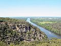
View of Nepean River from just south of Penrith.
-
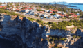
Eastern suburb of Vaucluse, which is situated on a clifftop.
-
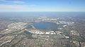
Aerial view of Sydney's western suburbs surrounding Prospect reservoir (looking west of Cumberland Plain towards Blue Mountains).
-
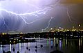
Thunderstorms and lightnings occasionally occur in the warm months.


