
Gori Municipality facts for kids
Quick facts for kids
Gori Municipality
გორის მუნიციპალიტეტი
|
|||
|---|---|---|---|
|
Municipality
|
|||

Gori Fortress
|
|||
|
|||

Location of Gori Municipality in Georgia
|
|||
| Country | |||
| Region | Shida Kartli | ||
| Capital | Gori | ||
| various | 1 town, 115 villages | ||
| Area | |||
| • Total | 1,352 km2 (522 sq mi) | ||
| Population
(2014)
|
|||
| • Total | 125,692 | ||
| • Density | 92.97/km2 (240.78/sq mi) | ||
| Time zone | UTC+4 | ||
| Website | Official site of shida kartli region: http://www.shidakartli.gov.ge/index.php?cat=77&par=6 | ||


Gori (Georgian: გორის მუნიციპალიტეტი, Goris municiṗaliṫeṫi) is a district of Georgia, in the region of Shida Kartli. After abolishment of former South Ossetian Autonomous Oblast, the Gori District included the territory of former Tskhinvali District. Some northern territories of the district are part of a self-proclaimed republic of South Ossetia and have not been under control of the Georgian government since 1992. It is bordered by the municipalities of Kaspi to the east, Borjomi and Tsalka to the south, and Kareli to the west. The area of Gori municipality is 1352 km2 and the population is 125,692 people. The administrative center of the municipality is the city of Gori.
Administrative Divisions
Gori municipality (those parts under de facto Georgian jurisdiction) is divided into 1 city (ქალაქი, kalaki), 22 communities (თეVillages), and ___ villages (სოფელი, sopeli):
Cities
Communities
- At'eni
- Akhalubani
- Berbuk'i
- Boshuri
- Dici
- Variani
- Zeghduleti
- K'araleti
- Mereti
- Mejvriskhevi
- Mghebriani
- Nikozi
- Saq'avre
- Sk'ra
- T'iniskhidi
- T'irdznisi
- T'q'viavi
- Kvakhvreli
- Shavshvebi
- Shindisi
- Dzevera
- Khidistavi
Villages
- At'eni
- Ts'edisi
- Bnavisi
- Olozi
- Ghvarebi
- Akhalubani
- Kveshi
- Akhrisi
- Adzvi
- Mumlaant K'ari
- Jariasheni
- Tsitsagiaant K'ari
- Kvemo Artsevi
- Berbuk'i
Images for kids
-
Გორიჯვარი.jpg
Gorijvari monastery
-
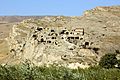
Uplistsikhe
-
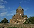
Ateni Sioni Church
-
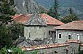
Zemo Nikozi church
-
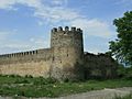
Shindisi Castle


.jpg)

See also
 In Spanish: Municipio de Gori para niños
