
Image: Airborne Lidar Bathymetric Technology

Size of this preview: 800 × 467 pixels. Other resolutions: 320 × 187 pixels | 850 × 496 pixels.
Original image (850 × 496 pixels, file size: 114 KB, MIME type: image/jpeg)
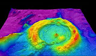
Description: High-resolution multibeam lidar map showing spectacularly faulted and deformed seafloor geology, in shaded relief and coloured by depth
Title: Airborne Lidar Bathymetric Technology
Credit: https://www.flickr.com/photos/oceanexplorergov/9267768683/
Author: NOAA Ocean Exploration & Research
Usage Terms: Public domain
License: Public domain
Attribution Required?: No
Image usage
The following page links to this image:

All content from Kiddle encyclopedia articles (including the article images and facts) can be freely used under Attribution-ShareAlike license, unless stated otherwise.