
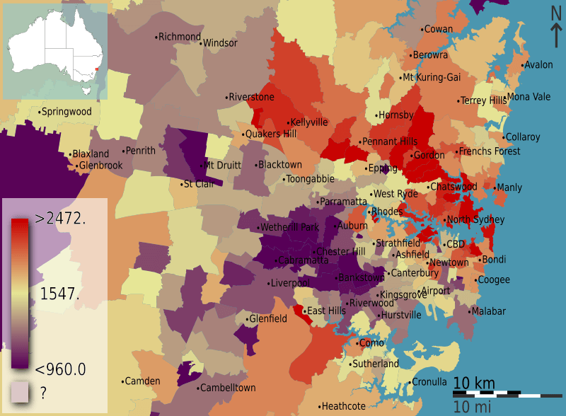
Image: Australian Census 2011 demographic map - Inner Sydney by POA - BCP field 0115 Median total household income weekly

Description: Median weekly total household income as a fraction of raw figure, in Inner Sydney, Australia, according to the 2011 census results. The map is divided into geographical subdivisions by Postal Area. Note the split scale above and below the median value.
Title: Australian Census 2011 demographic map - Inner Sydney by POA - BCP field 0115 Median total household income weekly
Credit: Own work This image is based on data from the Australian 2011 Census of Population and Housing compiled by the Australian Bureau of Statistics. The data plotted is from the Basic Community Profile, field 115 entitled "Median total household income weekly". The raw data is made available as part of datapacks (download details) and is licensed under the Creative Commons Attribution 2.5 license (Australia). English | +/−
Author: Toby Hudson based on data from the Australian Bureau of Statistics
Usage Terms: Creative Commons Attribution-Share Alike 3.0 au
License: CC BY-SA 3.0 au
License Link: http://creativecommons.org/licenses/by-sa/3.0/au/deed.en
Attribution Required?: Yes
Image usage
The following page links to this image:
