
Image: Bulgaria-geographic map-en

Size of this PNG preview of this SVG file: 800 × 529 pixels. Other resolution: 320 × 212 pixels.
Original image (SVG file, nominally 2,483 × 1,642 pixels, file size: 3.96 MB)
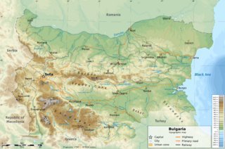
Description: Geographic map of Bulgaria (in English) UTM projection, WGS84 datum Geographic limits of the map:
West: 22.1° E East: 28.9° E North: 44.4° N South: 41.1° NSources of data:
Topography: NASA SRTM30; Bathymetry: ETOPO1; Transport, Rivers, Places: OpenStreetMap
Author: Ikonact
Usage Terms: Creative Commons Attribution-Share Alike 3.0
License: CC-BY-SA-3.0
License Link: http://creativecommons.org/licenses/by-sa/3.0/
Attribution Required?: Yes
Image usage
The following page links to this image:

All content from Kiddle encyclopedia articles (including the article images and facts) can be freely used under Attribution-ShareAlike license, unless stated otherwise.