
Image: Captaincy General of Chile, 1775

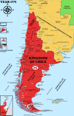
Description: Map of the Captaincy General of Chile or Kingdom of Chile in 1775. Boundaries based on the 1775 map of South America by Juan de la Cruz Cano y Olmedilla and the 1973 general map of the Kingdom of Chile by Andrés Baleato. It includes all the territories assigned de iure without prejudice of whether they had effective possession. Among these are the Magellanic Lands (Modern Chile or Patagonia), Atacama, the Province of Cuyo (segregated a year later), Chiloé, San Carlos Island (Rapa Nui), Terra Australis (Antarctica), among other territories. It includes settlements in force in 1775 as well as those destroyed in the Araucanía area and abandoned in the Strait of Magellan.
Title: Captaincy General of Chile, 1775
Credit: Chile location map (+claims, 1775).svg Gobernación de la Terra Australis (1539-1555), España.svg This file was derived from: Chile location map.svg by NordNordWest Reino de Chile según Juan de la Cruz Cano y Olmedilla, 1775.jpg Límite entre Chile y Perú en el río Loa, Plano General del Reyno de Chile en la América Meridional de Andrés Baleato (1793).jpg Own work [1] [2] [3] [4] [5] [6] [7] [8] [9] [10] [11] [12] [13] [14] [15] [16] [17] [18] Los Títulos Históricos: Historia de las fronteras de Chile, 1980, Lagos Carmona, Guillermo. "(p. 197) We note that the Loa river is at 22 degrees and that Baleato, in 1793, indicated 21.5 degrees for the beginning of the Kingdom of Chile, with the Loa at its mouth in the Pacific. (...) (p. 540) According to the Map of Cano y Olmedilla, the limit of the Kingdom of Chile "(...) through the desert of Atacama (...) From here it turns to the S., S.E., S.E., and S., keeping in general this last course until near the 29° parallel, from where it takes a S.E. direction. SE. and S., generally keeping this last course until the vicinity of the 29° parallel, from where it takes a S.E. direction, skirting to the east the 'Province of Cuyo' which, of course, appears to be included in the territory of the Kingdom of Chile. In the latitude of 32°30' the line turns to the S.W. until reaching the Quinto river, which, as the legend says 'communicates by channels with the Saladillo in time of floods'. It follows the river down to the meridian 316°, counting to the E. of Tenerife, where it turns a stretch until it reaches the Hueuque-Leuvu river (or Barrancas river) at 371/2° latitude. From here it runs along the river for a stretch to the S.E., and then turns to the E. and falls into the Atlantic Sea in the vicinity of parallel 37° between Cape Lobos and Cape Corrientes", "a little north of the current Mar del Plata". (...) (p. 543) In this document it is seen that those of the province of Cuyo end to the south at the source of the Diamante River, and that from that point to the east, the dividing line goes to the point where the Quinto River crosses the road that goes from Santiago to Buenos Aires."
Author: map by: Janitoalevic Original map: .mw-parser-output .commons-creator-table{background-color:#f0f0ff;box-sizing:border-box;font-size:95%;text-align:start}.mw-parser-output .commons-creator-table>tbody>tr{vertical-align:top}.mw-parser-output .commons-creator-table>tbody>tr>th{background-color:#e0e0ee;font-weight:bold;text-align:start}@media(max-width:719px){.mw-parser-output .commons-creator-table,.mw-parser-output .commons-creator-table>tbody{display:block;width:100%}.mw-parser-output .commons-creator-table>tbody{border-right:1px solid #aaa;border-bottom:1px solid #aaa}.mw-parser-output .commons-creator-table>tbody>tr{border-top:1px solid #aaa;display:flex;flex-wrap:wrap}.mw-parser-output .commons-creator-table>tbody>tr>th{border-left:1px solid #aaa;padding:2px;flex:1 1 100%}.mw-parser-output .commons-creator-table>tbody>tr>td{border-left:1px solid #aaa;padding:2px;flex:1 1}}@media(min-width:720px){.mw-parser-output .commons-creator-table{border:1px solid #aaa;border-collapse:collapse;border-spacing:0;padding:5px}.mw-parser-output .commons-creator-table>tbody>tr>th,.mw-parser-output .commons-creator-table>tbody>tr>td{border:1px solid #aaa;padding:2px}.mw-parser-output .commons-creator-table>tbody>tr>.halfwidth{max-width:10em}.mw-parser-output .commons-creator-table>tbody>tr>.fullwidth{max-width:20em}}Juan de la Cruz Cano y Olmedilla (1734–1790) Alternative names Juan de la Cruz Cano; Juan de la Cruz Cano y Holmedilla; Juan De La Cruz Cano Y Homedilla; Juan de la Cruz; Juan de la Cruz Cano Olmedilla; Juan de La Cruz Cano y OlmedillaDescription Spanish cartographerDate of birth/death 14 May 1734 15 February 1790 Location of birth/death Madrid MadridAuthority file : Q1710699 VIAF: 71443223 ISNI: 0000 0000 6639 6993 ULAN: 500038863 LCCN: n82234490 GND: 121284182 WorldCatcreator QS:P170,Q1710699 Andrés Baleato Base map: File:Chile location map.svg by NordNordWest
Usage Terms: Creative Commons Attribution-Share Alike 4.0
License: CC BY-SA 4.0
License Link: https://creativecommons.org/licenses/by-sa/4.0
Attribution Required?: Yes
Image usage
The following 2 pages link to this image:
