
Image: Roman fortificationsinnorthernScotland2
No higher resolution available.
Roman_fortificationsinnorthernScotland2.png (500 × 298 pixels, file size: 49 KB, MIME type: image/png)
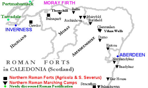
Description: I have added - to my first map (File:RomanFortsNorthernScotland.gif) - in green the newly discovered Roman Fortifications (Tarradale & Portmahomack) north of Inverness. Portmahomack is in Ross-shire. Galacantray is in Nairnshire.
Title: Roman fortificationsinnorthernScotland2
Credit: No machine-readable source provided. Own work assumed (based on copyright claims).
Author: No machine-readable author provided. Paul0559 assumed (based on copyright claims).
Usage Terms: Public domain
License: Public domain
Attribution Required?: No
Image usage
The following 4 pages link to this image:

All content from Kiddle encyclopedia articles (including the article images and facts) can be freely used under Attribution-ShareAlike license, unless stated otherwise.