
Image: Saguenaymap
No higher resolution available.
Saguenaymap.png (300 × 300 pixels, file size: 45 KB, MIME type: image/png)
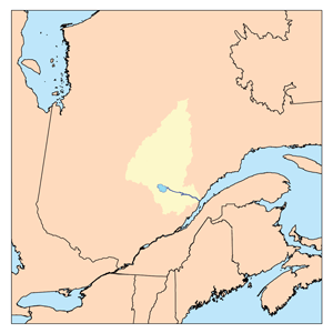
Description: This is a map of the Saguenay River watershed. Lac Saint-Jean is also shown. I, Karl Musser, created it based on USGS and Digital Chart of the World data.
Title: Saguenaymap
Credit: No machine-readable source provided. Own work assumed (based on copyright claims).
Author: No machine-readable author provided. Kmusser assumed (based on copyright claims).
Usage Terms: Creative Commons Attribution-Share Alike 2.5
License: CC BY-SA 2.5
License Link: https://creativecommons.org/licenses/by-sa/2.5
Attribution Required?: Yes
Image usage
The following 17 pages link to this image:
- Aigremont Lake
- Boisvert River (Normandin River tributary)
- Bouteroue Creek
- Chigoubiche Lake
- Coquille River (Normandin River tributary)
- Frontenac Lake (Milieu River)
- Ha! Ha! River (Saguenay River tributary)
- Hogan River
- Manouane River (Péribonka River tributary)
- Marquette River
- Marquette River West
- Maskoskanaw River
- Normandin River
- Rivière des Cèdres (Ha! Ha! River tributary)
- Rivière du Milieu (Normandin River tributary)
- Saguenay River
- Vimont Lake

All content from Kiddle encyclopedia articles (including the article images and facts) can be freely used under Attribution-ShareAlike license, unless stated otherwise.