
Image: Santa Fe of New Mexico (location map scheme)

Size of this PNG preview of this SVG file: 500 × 475 pixels. Other resolution: 253 × 240 pixels.
Original image (SVG file, nominally 500 × 475 pixels, file size: 565 KB)
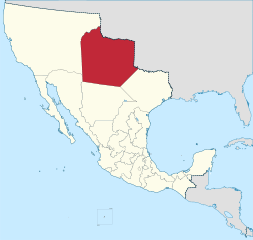
Description: Map of the former Mexican territory of Nuevo México in 1824. Included all or part of present day U.S. New Mexico, Colorado, and Texas, and Mexican Chihuahua and Sonora.
Title: Santa Fe of New Mexico (location map scheme)
Credit: This vector graphics image was created with Adobe Illustrator.
Author: File:Primera Republica Federal 1825.PNG : Hpav7 Derivative work : Giggette
Usage Terms: Creative Commons Attribution-Share Alike 3.0
License: CC BY-SA 3.0
License Link: http://creativecommons.org/licenses/by-sa/3.0
Attribution Required?: Yes
Image usage
The following page links to this image:

All content from Kiddle encyclopedia articles (including the article images and facts) can be freely used under Attribution-ShareAlike license, unless stated otherwise.
.svg)