
Image: Tectonic plates boundaries World map Wt 180degE centered-en

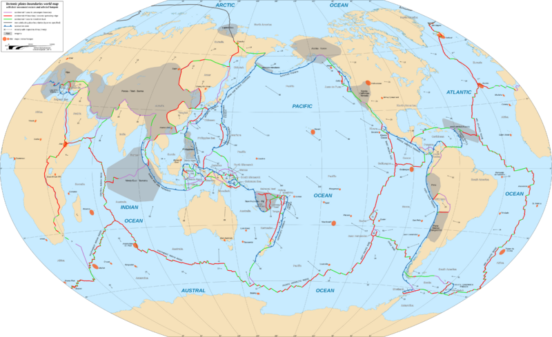
Description: World map in English showing the tectonic plates boundaries with their movement vectors and selected hotspots.
Title: Tectonic plates boundaries World map Wt 180degE centered-en
Credit: Background map: GSHHG v.2.3.7 (public domain); Plates: Prof. Peter Bird; Southwest Pacific Plates’ site; College of Earth and Mineral Sciences, Penn State; Kenneth W. Hudnut from USGS, in Earthquake Spectra, June 2006; USGS: This Dynamic Planet; The Antarctic Tectonic Region’s site; Hotspots: Earth Magazine; Written In Stone blogspot, by Dr. Jack Share; Bernhard Steinberger: Plumes in a convecting mantle: Models and observations for individual hotspots, in Journal of Geophysical Research, May 2000; Dr. Peter Schmidt; Ridges and trenches: USGS map; USGS map; Columbia University map.
Author: Eric Gaba (Sting - fr:Sting)
Permission: Attribution and Share-Alike required Any use of this map can be made as long as you credit me (Eric Gaba – Wikimedia Commons user: Sting) as the author and distribute the copies and derivative works under the same license(s) that the one(s) stated below. A message with a reply address would also be greatly appreciated.
Usage Terms: Creative Commons Attribution-Share Alike 3.0
License: CC BY-SA 3.0
License Link: https://creativecommons.org/licenses/by-sa/3.0
Attribution Required?: Yes
Image usage
The following 2 pages link to this image:
