
Image: USA Mississippi Tupelo area NPS map
No higher resolution available.
USA_Mississippi_Tupelo_area_NPS_map.jpg (285 × 305 pixels, file size: 28 KB, MIME type: image/jpeg)
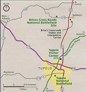
Description: Area map of Tupelo, Mississippi, showing city limits, roads, and national parks or historic landmarks. Map by US NPS.
Title: USA Mississippi Tupelo area NPS map
Credit: US National Park Service webpage: http://pagebang.com/cgi/nph-proxy.cgi/111011A/http/www.nps.gov/brcr/planyourvisit/index.htm
Author: US Federal Government: Department of the Interior
Usage Terms: Public domain
License: Public domain
Attribution Required?: No
Image usage
The following 4 pages link to this image:

All content from Kiddle encyclopedia articles (including the article images and facts) can be freely used under Attribution-ShareAlike license, unless stated otherwise.