
List of Grade A listed buildings in County Antrim facts for kids

County Antrim, located in Northern Ireland, is home to many amazing old buildings and structures. Some of these are so special that they are officially "listed" to protect them. This means they are considered very important because of their history or their beautiful design. In Northern Ireland, the most important of these are called "Grade A" listed buildings. County Antrim has 79 of these incredible places, and 37 of them are in the city of Belfast.
Contents
What Are Listed Buildings?
A "listed building" is a special building or structure that the government has officially marked as having "special architectural or historic interest." Think of it like putting a building on a very important protected list!
Grade A: The Most Important Buildings
"Grade A" buildings are the most important ones in Northern Ireland. They are like the superstars of old buildings! This includes buildings with amazing designs and those that are the best examples of a certain style or time period.
Why Protect These Buildings?
Once a building is listed, it means it's protected. You can't make big changes to its structure or its special features without getting permission first. This helps make sure these important places stay safe and look their best for many years to come. This protection started later in Northern Ireland than in other parts of the UK. The first laws to protect these buildings came out in 1972, and the current laws were put in place in 1991.
Who Protects Them?
The Department for Communities (DfC) in the Northern Ireland Executive is in charge of finding and listing these special buildings. They started looking for important buildings in 1974. They finished their first big search in 1994, but they are still doing a second search to update all the information. All the details about these buildings are kept in a public database called the Northern Ireland Buildings Database. They use special rules to decide if a building is important enough to be listed.
Some Famous Grade A Buildings in County Antrim
County Antrim has many fantastic Grade A listed buildings. Here are just a few examples that show the variety of these special places:
Historic Castles and Estates
- Shane's Castle Camellia House and Ruins, Antrim: Shane's Castle is a historic estate with beautiful ruins and a special glass house called the Camellia House. It's a great example of old country estates.
- Castle Upton, Templepatrick: This grand country house and its surrounding features, like the Adam Yard and the entrance gates, are also Grade A listed. Even the Templeton Mausoleum on the grounds is protected.
- Galgorm Castle, Ballymena: Another impressive country house, Galgorm Castle, is a significant historical building in Ballymena.
- Glenarm Castle, Glenarm: This beautiful castle is a major landmark in Glenarm, known for its stunning architecture and grounds.
- Ballygally Castle, Larne: Now a hotel, Ballygally Castle is a unique and historic building right on the coast.
Important Churches and Cathedrals
- Randalstown Presbyterian Church, Randalstown: This old church is an important religious building in the area.
- Non-Subscribing Presbyterian Church, Crumlin: This church in Crumlin is also recognized for its special design and history.
- Moravian Church, Gracehill: Located in the historic village of Gracehill, this church and its early memorials are very important.
- St. Peter's Cathedral, Belfast: A major religious building in Belfast, known for its grand design.
- St. Malachy's Church, Belfast: This church in Belfast is celebrated for its unique and beautiful architecture.
- St. George's Church, Belfast: Another significant church in Belfast, recognized for its historical and architectural value.
- First Presbyterian Church (Non-Subscribing), Belfast: This church on Rosemary Street is also a protected Grade A building.
- St. Anne's Cathedral, Belfast: A large and impressive cathedral in the heart of Belfast.
- St. Nicholas' Church, Carrickfergus: This historic church in Carrickfergus is an important part of the town's heritage.
- Christ Church Cathedral, Lisburn: The main cathedral in Lisburn, a very important religious site.
- Holy Trinity Church, Ballycastle: This church in Ballycastle is also a Grade A listed building.
Key Buildings in Belfast
Belfast has many Grade A listed buildings, showing its rich history and grand architecture:
- Belfast City Hall: This iconic building in Donegall Square is the heart of Belfast's civic life.
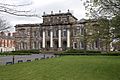
- Queen's University Belfast (Lanyon Building): The main building of the university is famous for its beautiful design.
- Elmwood Hall, Belfast: A historic hall used for events and performances.
- Grand Opera House, Belfast: A stunning theatre where many shows are performed.
- Crown Liquor Saloon, Belfast: A very famous and beautifully decorated pub.
- Ulster Hall, Belfast: A historic concert and event venue.
- County Gaol, Crumlin Road, Belfast: This former prison is now a historic site.
- Belfast Charitable Institution (Clifton House): An old residential home with a long history of helping people.
- Custom House, Belfast: A grand building that used to handle customs for the port.
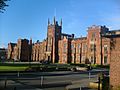
- Royal Belfast Academical Institution, Belfast: A historic school building.
- Royal Courts Of Justice, Belfast: The main courthouse building.
- McHugh's Bar, Belfast: One of Belfast's oldest buildings, now a popular bar and restaurant.
Other Notable Structures
- Former Control Tower, Langford Lodge Airfield, Crumlin: An important World War II structure.
- Railway Viaducts, Bleach Green Junction, Newtownabbey: These two railway bridges are recognized for their engineering and historical importance.
Images for kids
-

Shane's Castle ruins
-

Long Canals and Round Pond, Antrim Castle Gardens
-

Castle Upton
-

Non-Subscribing Presbyterian Church, Crumlin
-

Galgorm Castle
-

Moravian Church, Gracehill
-

Early memorials in graveyard of Moravian Church, Gracehill
-

Benvarden House
-

St. Peter's Cathedral, Belfast
-

St. Mark's Church, Holywood Road, Dundela, Belfast
-

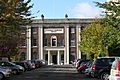
Main Building, Stranmillis College
-

The Palm House, Belfast Botanic Gardens
-
Assembly's College, Belfast
-
Lanyon Building, Queen's University Belfast
-

Elmwood Hall, Belfast
-

Grand Opera House, Belfast
-

Crown Liquor Saloon, Belfast
-

St. Malachy's Church, Belfast
-

Ulster Hall, Belfast
-

County Gaol, Crumlin Road, Belfast
-

Belfast Charitable Institution (Clifton House)
-

Belfast City Hall
-

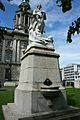
First Marquis of Dufferin Memorial
-

Boer War Monument, Belfast
-
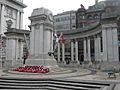
Cenotaph and Garden of Remembrance, Belfast
-
Titanic Monument, Belfast
-

Sir Edward Harland Memorial, Belfast
-

Sir Robert McMordie Memorial, Belfast
-

Victoria Monument, Belfast
-

Sir James Haslett Memorial, Belfast
-

Former Water Office, Donegall Square, Belfast
-
Royal Belfast Academical Institution
-

St. George's Church, Belfast
-

McCausland's Building (Hotel), Belfast
-

First Presbyterian Church (Non-Subscribing), Belfast
-

Former Ulster Bank Head Office (Merchant Hotel)
-

Custom House, Belfast
-

St. Anne's Cathedral, Belfast
-

Harbour Office, Belfast
-

Tesco (former Provincial Bank of Ireland)
-

Old Museum Buildings, Belfast
-

Royal Courts Of Justice, Belfast
-

McHugh's Bar, Belfast
-

St. Nicholas' Church, Carrickfergus
-

Glenarm Castle
-

Ballygally Castle
-

Christ Church Cathedral, Lisburn
-

Fountain, Castle Gardens, Lisburn
-

Christ Church, Derriaghy
-
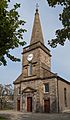
Holy Trinity Church, Ballycastle


_Presbyterian_Church_-_geograph.org.uk_-_67942.jpg)

,_September_2009.JPG)


.JPG)


.jpg)


_-_geograph.org.uk_-_383944.jpg)


.JPG)
,_October_2009.JPG)
.JPG)
_41_Rosemary_St._Belfast.jpg)


.jpg)
.jpg)

,_October_2009.JPG)


_-_geograph.org.uk_-_58794.jpg)

See also
