
Rangpur Division facts for kids
Quick facts for kids
Rangpur Division
রংপুর বিভাগ
|
|
|---|---|

Map of Rangpur Division in red
|
|
| Country | |
| Area | |
| • Total | 16,320.26 km2 (6,301.29 sq mi) |
| Population
(2011 census)
|
|
| • Total | 15,665,000 |
| • Density | 959.850/km2 (2,486.00/sq mi) |
| Time zone | UTC+6 (BST) |
Rangpur Division became Bangladesh's seventh division on January 25, 2010. Before that, it was the northern 8 districts of the Rajshahi Division. The Rangpur division has eight districts: Rangpur, Dinajpur, Kurigram, Gaibandha, Nilphamari, Panchagarh, Thakurgaon, and Lalmonirhat. There are 58 subdistricts under these eight districts. Rangpur is the northernmost division of Bangladesh. There were 15,665,000 people at the 2011 Census. The major cities of this new division are Rangpur and Dinajpur. Rangpur has well-known schools, such as Carmichael College, Hajee Mohammad Danesh Science and Technology University, Rangpur Medical College, Rangpur Cadet College, and Begum Rokeya University.
History
In 1947 it became a part of the former East Pakistan province as a district.
 |
West Bengal, India | Assam, India | |
|
| West Bengal, India | Meghalaya, India | |||
| Rajshahi Division | Dhaka Division |
Images for kids
-
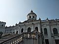
Tajhat Palace, situated in the Rangpur City, is one of the most visited monuments within the Division.

See also
 In Spanish: División de Rangpur para niños
