
Image: Map of Clear Creek County, Colorado

Size of this preview: 800 × 559 pixels. Other resolutions: 320 × 224 pixels | 1,829 × 1,279 pixels.
Original image (1,829 × 1,279 pixels, file size: 14 KB, MIME type: image/png)
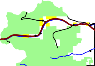
Description: A map of Clear Creek County, Colorado. The dark red line is Interstate 70. Black lines are other roads. Dots are towns. The light green area is Arapaho National Forest and other national forest. Yellow is BLM land. David Benbennick made this map with data from nationalatlas.gov. Eventually I'll upload the Metapost script I used. In the mean time, see map.mp.
Title: Map of Clear Creek County, Colorado
Credit: Own work
Author: David Benbennick
Usage Terms: Public domain
License: Public domain
Attribution Required?: No
Image usage
The following page links to this image:

All content from Kiddle encyclopedia articles (including the article images and facts) can be freely used under Attribution-ShareAlike license, unless stated otherwise.