
Brahmanbaria District facts for kids
Quick facts for kids
Brahmanbaria
ব্রাহ্মণবাড়িয়া
|
|
|---|---|

Location of Brahmanbaria in Bangladesh
|
|
| Country | |
| Division | Chittagong Division |
| Area | |
| • Total | 1,927.11 km2 (744.06 sq mi) |
| Bhadughar Meela = Bhadughar Boishahi Meela (14th Boishah) | |
| Population
(1991)
|
|
| • Total | 2,365,880 |
| • Density | 1,227.683/km2 (3,179.684/sq mi) |
| Literacy rate | |
| • Total | 26.6% |
| Time zone | UTC+6 (BST) |
| • Summer (DST) | UTC+7 (BDST) |
| Postal code |
3400
|
| Website | http://www.dcbrahmanbaria.gov.bd/ |
Brahmanbaria (Bengali: ব্রাহ্মণবাড়িয়া Bramhonbaŗia) is a district in east-central Bangladesh. It is a part of the Chittagong Division. It was part of greater Comilla District until 1984. Before 1830 the Sarail Pargana was a part of Mymensingh district. The district has 4 municipalities, 39 wards, 97 mahallas, 7 upazilas, 98 union parishads, 1052 mouzas and 1329 villages.
Geography
Brahmanbaria District is located at the east-central region of Bangladesh. It has a total area of 1927.11 km². Brahmanbaria is bordered by Kishoreganj District and Habiganj District on the north, Comilla District on the south, Habiganj District and Tripura State, India on the east and Meghna River, Kishoreganj District, Narsingdi District and Narayanganj District on the west.
The district is mainly by low-lying land with small hills.
Images for kids
-
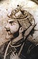
Isa Khan, leader of Bengal's 16th-century Baro-Bhuiyan rebel chieftains, had his capital situated in Sarail.
-
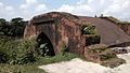
The Hatirpul, a medieval elephant pass built in Bariura.
-
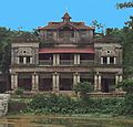
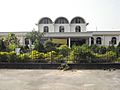
The Gokarna Nawab Bari Complex, built by Nawab Sir Syed Shamsul Huda in Nasirnagar.
-
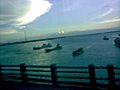
Port of Ashuganj on Meghna River, will be largest port by 2030.
-
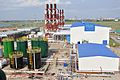
Power plant
-
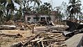
Tornado aftermath in Brahmanbaria, 2013.
-
Akhaura-the largest railway junction in Bangladesh.


.jpg)

See also
 In Spanish: Brahmanbaria (zila) para niños
