County of Livingstone, Queensland facts for kids
Quick facts for kids LivingstoneQueensland |
|||||||||||||||
|---|---|---|---|---|---|---|---|---|---|---|---|---|---|---|---|

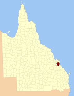
Location within Queensland
|
|||||||||||||||
|
|||||||||||||||
The County of Livingstone is a special way of dividing land in Queensland, Australia. Think of it like a big, official area on a map, mainly used for keeping records about land. It's centered around the city of Rockhampton and covers most of the Rockhampton Region.
Contents
About Livingstone County
Livingstone County is an important area in Queensland, Australia. It's a type of land division, which means it's a way the government organizes and keeps track of different parts of the land. This county is mostly made up of the Rockhampton Region, with the city of Rockhampton right at its heart.
How Livingstone County Was Created
Livingstone County was officially created a long time ago, on September 1, 1855. This happened through a special announcement from the King or Queen, called a "royal proclamation." It was part of a law about land in Australia.
Later, on March 7, 1901, the Governor of Queensland (who is like the state's leader) made another official announcement. This one legally divided Queensland into many counties, including Livingstone.
Where is Livingstone County?
The official description of Livingstone County tells us exactly where its borders are.
- To the south, it borders the county of Deas Thompson.
- To the west, it has borders with several smaller areas called parishes.
- To the north, it also borders other parishes.
- To the east, it meets the Pacific Ocean.
The county also includes some nearby islands, like Great Keppel Island and North Keppel Island.
Parishes of Livingstone County
Livingstone County is further divided into smaller areas called parishes. These are like smaller neighborhoods or districts within the county. Each parish has its own name and location. Some parishes even contain towns or suburbs you might know!
Here is a list of the parishes within Livingstone County:
| Parish | LGA | Coordinates | Towns |
|---|---|---|---|
| Archer | Rockhampton | 23°22′S 150°36′E / 23.367°S 150.600°E | North Rockhampton, Lakes Creek |
| Barmoya | Rockhampton | 23°07′S 150°34′E / 23.117°S 150.567°E | |
| Bouldercombe | Rockhampton | 23°32′S 150°26′E / 23.533°S 150.433°E | Bouldercombe |
| Calioran | Rockhampton | 23°11′S 150°20′E / 23.183°S 150.333°E | |
| Canoona | Rockhampton | 22°57′S 150°21′E / 22.950°S 150.350°E | |
| Cawarral | Rockhampton | 23°14′S 150°38′E / 23.233°S 150.633°E | Cawarral |
| Cecil | Rockhampton | 23°33′S 150°39′E / 23.550°S 150.650°E | |
| Faraday | Rockhampton | 23°16′S 150°16′E / 23.267°S 150.267°E | Ridgelands |
| Fitzroy | Rockhampton | 23°12′S 150°27′E / 23.200°S 150.450°E | The Caves |
| Gavial | Rockhampton | 23°28′S 150°35′E / 23.467°S 150.583°E | Midgee |
| Gracemere | Rockhampton | 23°27′S 150°27′E / 23.450°S 150.450°E | Gracemere, Kabra |
| Herbert | Rockhampton | 23°28′S 150°51′E / 23.467°S 150.850°E | |
| Hewittville | Rockhampton | 23°14′S 150°46′E / 23.233°S 150.767°E | Emu Park, Cooee Bay |
| Jardine | Rockhampton | 23°05′S 150°25′E / 23.083°S 150.417°E | Milman |
| Karkol | Rockhampton | 23°21′S 150°26′E / 23.350°S 150.433°E | |
| Keppel | Rockhampton | 23°08′S 150°55′E / 23.133°S 150.917°E | Great Keppel Island |
| Limestone | Rockhampton | 23°22′S 150°15′E / 23.367°S 150.250°E | |
| Meadow Flats | Rockhampton | 23°21′S 150°49′E / 23.350°S 150.817°E | Keppel Sands |
| Moonmera | Rockhampton | 23°36′S 150°19′E / 23.600°S 150.317°E | |
| Morinish | Rockhampton | 23°12′S 150°10′E / 23.200°S 150.167°E | |
| Murchison | Rockhampton | 23°17′S 150°30′E / 23.283°S 150.500°E | Norman Gardens, Kawana |
| Neerkol | Rockhampton | 23°25′S 150°18′E / 23.417°S 150.300°E | |
| Nicholson | Rockhampton | 23°18′S 150°24′E / 23.300°S 150.400°E | Alton Downs |
| Playfair | Rockhampton | 23°33′S 150°11′E / 23.550°S 150.183°E | Wycarbah |
| Plews | Rockhampton | 23°35′S 150°33′E / 23.583°S 150.550°E | |
| Rockhampton | Rockhampton | 23°24′S 150°30′E / 23.400°S 150.500°E | Rockhampton, Port Curtis |
| Rosslyn | Rockhampton | 22°59′S 150°33′E / 22.983°S 150.550°E | Rossmoya |
| Stanwell | Rockhampton | 23°29′S 150°16′E / 23.483°S 150.267°E | Stanwell |
| Thozet | Rockhampton | 23°27′S 150°41′E / 23.450°S 150.683°E | |
| Werribee | Rockhampton | 22°52′S 150°29′E / 22.867°S 150.483°E | |
| Wiseman | Rockhampton | 23°22′S 150°23′E / 23.367°S 150.383°E | |
| Yaamba | Rockhampton | 23°04′S 150°18′E / 23.067°S 150.300°E | Yaamba |
| Yeppoon | Rockhampton | 23°07′S 150°43′E / 23.117°S 150.717°E | Yeppoon |
External Links
You can find the main coordinates for Livingstone County here:
 | Shirley Ann Jackson |
 | Garett Morgan |
 | J. Ernest Wilkins Jr. |
 | Elijah McCoy |

