
Hardwick, Vermont facts for kids
Quick facts for kids
Hardwick, Vermont
|
|
|---|---|

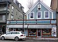
North Main Street
|
|

Hardwick, Vermont
|
|

Hardwick, Vermont
Location in the United States
|
|
| Country | United States |
| State | Vermont |
| County | Caledonia |
| Chartered | 1781 |
| Communities | Hardwick East Hardwick Hardwick Center Hardwick Street Mackville |
| Area | |
| • Total | 39.0 sq mi (101.1 km2) |
| • Land | 38.6 sq mi (100.0 km2) |
| • Water | 0.4 sq mi (1.0 km2) |
| Elevation | 1,339 ft (408 m) |
| Population
(2020)
|
|
| • Total | 2,920 |
| • Density | 76/sq mi (29.2/km2) |
| Time zone | UTC-5 (Eastern (EST)) |
| • Summer (DST) | UTC-4 (EDT) |
| ZIP codes |
05843, 05836 (in East Hardwick)
|
| Area code(s) | 802 Exchange: 472 |
| FIPS code | 50-31825 |
| GNIS feature ID | 1462115 |
Hardwick is a town in Caledonia County, Vermont, United States. The population was 2,920 at the 2020 census. It contains the unincorporated villages of Hardwick, East Hardwick, and Mackville. The town is a commercial center for the region's farming population.
The main settlement of Hardwick in the center of the town, formerly an incorporated village, is since 1988 a census-designated place (CDP), with a population of 1,269 at the 2020 census.
Contents
History
During the Revolutionary War, General George Washington ordered construction of the Bayley-Hazen Military Road to provide access into the interior of Vermont. It would prompt the development and settlement of Hardwick and East Hardwick.
The town was granted by the Vermont General Assembly on November 7, 1780, then chartered on August 19, 1781, to Danforth Keyes and 66 others, some of whom were from Hardwick, Massachusetts. Permanent settlement began in 1793 when several families named Norris arrived from New Hampshire. By 1859, when the population reached 1,402, the town had several sawmills and gristmills on the Lamoille River. There were also two tanneries. Over the years, other industries would include a woolen mill, tinware shop, and carriage factory.

The predominant business following the Civil War was granite quarrying, especially after the Portland & Ogdensburg Railway opened service through the town and facilitated shipment of stone. While most of the granite was quarried in nearby Woodbury, the stone was dressed and finished in Hardwick, largely at "Granite Junction", where the rail lines met. Hardwick became known as the "Building Granite Center of the World". By 1906, 1,200 people were employed in the industry. Buildings around the country made with Hardwick granite include the Pennsylvania State Capitol, Chicago City Hall, and the Old Post Office Building in Washington, D.C., as well as numerous city halls and custom houses.
Hardwick Village disincorporated in 1988 and merged with the town.
In 2011, the office manager of the municipal electric department was accused of embezzling $1.6 million over a period of 12 years. The FBI investigated, and she was charged in federal court and found guilty.
Geography
Hardwick is the westernmost town in Caledonia County. It is bordered by the Caledonia County towns of Walden and Stannard to the east. The town of Greensboro, in Orleans County, is to the north. Lamoille County is to the west, containing the town of Wolcott to the west and Elmore to the southwest. To the south, in Washington County, are the towns of Woodbury and Cabot. According to the United States Census Bureau, Hardwick has a total area of 39.0 square miles (101.1 km2), of which 38.6 square miles (100.0 km2) is land and 0.39 square miles (1.0 km2), or 1.02%, is water. The CDP (town center) of Hardwick has a total area of 1.46 square miles (3.77 km2), of which 1.44 square miles (3.73 km2) is land and 0.015 square miles (0.04 km2), or 1.16%, is water.
Hardwick is drained by the Lamoille River and its tributaries, flowing west to Lake Champlain. The highest point in Hardwick is the summit of Jeudevine Mountain in the northern corner of the town, at 1,831 feet (558 m) above sea level.
The town is crossed by Vermont Route 14, Vermont Route 15, and Vermont Route 16.
Demographics
| Historical population | |||
|---|---|---|---|
| Census | Pop. | %± | |
| 1790 | 3 | — | |
| 1800 | 260 | 8,566.7% | |
| 1810 | 735 | 182.7% | |
| 1820 | 867 | 18.0% | |
| 1830 | 1,216 | 40.3% | |
| 1840 | 1,354 | 11.3% | |
| 1850 | 1,402 | 3.5% | |
| 1860 | 1,369 | −2.4% | |
| 1870 | 1,519 | 11.0% | |
| 1880 | 1,484 | −2.3% | |
| 1890 | 1,547 | 4.2% | |
| 1900 | 2,466 | 59.4% | |
| 1910 | 3,201 | 29.8% | |
| 1920 | 2,641 | −17.5% | |
| 1930 | 2,720 | 3.0% | |
| 1940 | 2,605 | −4.2% | |
| 1950 | 2,629 | 0.9% | |
| 1960 | 2,349 | −10.7% | |
| 1970 | 2,466 | 5.0% | |
| 1980 | 2,613 | 6.0% | |
| 1990 | 2,964 | 13.4% | |
| 2000 | 3,174 | 7.1% | |
| 2010 | 3,010 | −5.2% | |
| 2020 | 2,920 | −3.0% | |
| U.S. Decennial Census | |||
As of the census of 2000, there were 3,174 people, 1,216 households, and 854 families residing in the town. The population density was 82.4 people per square mile (31.8/km2). There were 1,407 housing units at an average density of 36.5 per square mile (14.1/km2). The racial makeup of the town was 97.89% White, 0.06% African American, 0.82% Native American, 0.09% Asian, 0.19% from other races, and 0.95% from two or more races. Hispanic or Latino of any race were 0.41% of the population.
There were 1,216 households, out of which 37.8% had children under the age of 18 living with them, 52.1% were married couples living together, 13.7% had a female householder with no husband present, and 29.7% were non-families. 22.5% of all households were made up of individuals, and 9.0% had someone living alone who was 65 years of age or older. The average household size was 2.61 and the average family size was 3.06.
In the town, the population was spread out, with 29.5% under the age of 18, 7.0% from 18 to 24, 28.9% from 25 to 44, 22.7% from 45 to 64, and 11.9% who were 65 years of age or older. The median age was 36 years. For every 100 females, there were 92.9 males. For every 100 females age 18 and over, there were 89.3 males.
Historic places

The town contains five places on the National Register of Historic Places:
- Building at 143 Highland Avenue — 143 Highland Ave. (added May 6, 2000)
- Cobb School — Jct. of Hardwick Town Hwy. 10 (Cobb School Rd.) and Sanborn Cemetery Rd. (added October 30, 1993)
- Downtown Hardwick Village Historic District — Brush St. (added April 10, 2004)
- Downtown Hardwick Village Historic District — Main, Church, Maple and Mill Sts. (added October 30, 1982)
- Hardwick Street Historic District — NE of Hardwick (added July 22, 1979)
Economy
Personal income
The median income for a household in the town was $33,636, and the median income for a family was $39,278. Males had a median income of $27,188 versus $21,732 for females. The per capita income for the town was $14,813. About 10.5% of families and 14.0% of the population were below the poverty line, including 16.3% of those under age 18 and 14.2% of those age 65 or over.
Agriculture
Several agribusinesses active in and around Hardwick, employing techniques of sustainable agriculture, have added an estimated 75-100 jobs to the area (through 2008). They operate the Vermont Food Venture Center, a "shared-use kitchen incubator for value-added and specialty food producers." The facility should generate the equivalent of 16 full-time jobs when fully operational.
Tourism
A gathering of the Society for Creative Anachronism has been an annual event.
On the last weekend in May, there is a Memorial Day parade, craft fair, and running race.
Notable people
- Guy W. Bailey, Secretary of State of Vermont and President of the University of Vermont
- Dustin Grow Cheever, politician
- Catherine Cate Coblentz, writer
- Philip Cummings, Spanish teacher, news analyst, public speaker
- Dorman Bridgman Eaton, lawyer and author
- Lee E. Emerson, 69th governor of Vermont
- Jim Fixx, author and jogging enthusiast
- Thomas J. D. Fuller, US congressman
- David H. Nichols, politician
- William H. Taylor, Associate Justice of the Vermont Supreme Court
-
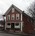
Hardwick Gazette building, 42 South Main Street
-
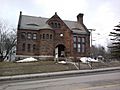
Jeudevine Library, 93 North Main Street
-
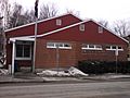
Hardwick Post Office, 52 Mill Street
-
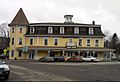
Historic Hardwick Inn, 4 South Main Street
-
Buffalo Mountain Food Co-operative, 39 South Main Street
-
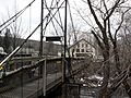
Footbridge over Lamoille River


Images for kids
-
Over Lamoille River.

See also
 In Spanish: Hardwick (Vermont) para niños
