Holzminden (district) facts for kids
Quick facts for kids
Holzminden
|
||
|---|---|---|
|
||
| Country | ||
| State | Lower Saxony | |
| Capital | Holzminden | |
| Area | ||
| • Total | 692 km2 (267 sq mi) | |
| Population
(2002)
|
||
| • Total | 80,300 | |
| • Density | 116.04/km2 (300.5/sq mi) | |
| Time zone | UTC+1 (CET) | |
| • Summer (DST) | UTC+2 (CEST) | |
| Vehicle registration | HOL | |
| Website | landkreis-holzminden.de | |
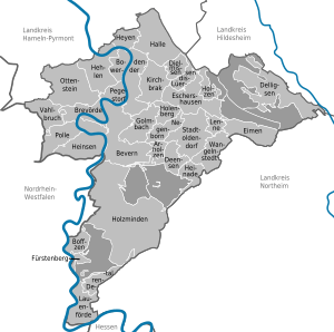
Holzminden is a district in Lower Saxony, Germany.
The district is located in the Weserbergland mountains. The Weser River forms the southwestern border of the district.
Towns and municipalities
| Towns | Samtgemeinden | |
|---|---|---|
|
|
|
| 1seat of the Samtgemeinde; 2town | ||
See also
 In Spanish: Distrito de Holzminden para niños

All content from Kiddle encyclopedia articles (including the article images and facts) can be freely used under Attribution-ShareAlike license, unless stated otherwise. Cite this article:
Holzminden (district) Facts for Kids. Kiddle Encyclopedia.


