
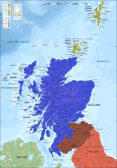
Image: 1334 Treaty of Newcastle

Size of this PNG preview of this SVG file: 417 × 599 pixels. Other resolution: 167 × 240 pixels.
Original image (SVG file, nominally 2,400 × 3,450 pixels, file size: 4.34 MB)
Description: Map showing counties claimed by England in the 1334 Treaty of Newcastle. Scotland (divided between supporters of David Bruce & supporters of Edward Balliol) England Counties claimed by England Norway
Title: 1334 Treaty of Newcastle
Credit: Own work This file was derived from: Scotland topographic map-en.svg Matches information on p. 131 of Sumption, Jonathan (1990). Trial by Battle. London: Faber and Faber. ISBN 978-0-57120-095-5.
Author: MrPenguin20
Usage Terms: Creative Commons Attribution-Share Alike 4.0
License: CC BY-SA 4.0
License Link: https://creativecommons.org/licenses/by-sa/4.0
Attribution Required?: Yes
Image usage
The following 3 pages link to this image:

All content from Kiddle encyclopedia articles (including the article images and facts) can be freely used under Attribution-ShareAlike license, unless stated otherwise.