
Image: 1646linemap
No higher resolution available.
1646linemap.jpg (300 × 250 pixels, file size: 19 KB, MIME type: image/jpeg)
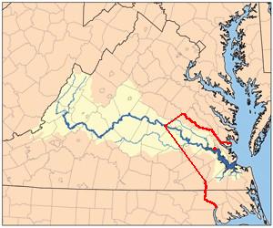
Description: Self-Made from Jamesrivermap.jpg, red line shows boundary between Virginia Colony and Tributary Indian tribes as established by Treaty of 1646 concluding Second Anglo-Powhatan War. Red dot on river shows Jamestown, capital of Virginia Colony.
Title: 1646linemap
Credit: Transferred from en.wikipedia to Commons by The Bushranger using CommonsHelper.
Author: Til Eulenspiegel at English Wikipedia
Usage Terms: Public domain
License: Public domain
Attribution Required?: No
Image usage
The following 4 pages link to this image:

All content from Kiddle encyclopedia articles (including the article images and facts) can be freely used under Attribution-ShareAlike license, unless stated otherwise.