
Image: 1671 Diyarbakır from Ottoman map of Tigris and Euphrates 2012 Kurşun Z Fig2
No higher resolution available.
1671_Diyarbakır_from_Ottoman_map_of_Tigris_and_Euphrates_2012_Kurşun_Z_Fig2.jpg (389 × 239 pixels, file size: 23 KB, MIME type: image/jpeg)
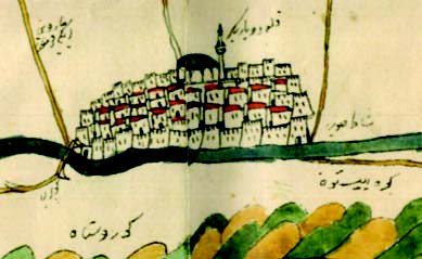
Description: The cities of Hasankeyf (left) and Diyarbekir (right) on the Tigris river. South is at the top. Detail from a 17th-century map of the Tigris and Euphrates now owned by Shaikh Hassan bin Muhammed al-Thani of Qatar. The map may have been drawn by the Ottoman traveler Evliya Çelebi.
Title: 1671 Diyarbakır from Ottoman map of Tigris and Euphrates 2012 Kurşun Z Fig2
Credit: Zekeriya, Kurşun (2012), “Does the Qatar Map of the Tigris and Euphrates belong to Evliya Çelebi?”, in Journal of Ottoman Studies [Osmanlı Araştırmaları][1], issue 39, pages 1–15
Author: Evliya Çelebi (1611 – 1682)
Usage Terms: Public domain
License: Public domain
Attribution Required?: No
Image usage
The following page links to this image:

All content from Kiddle encyclopedia articles (including the article images and facts) can be freely used under Attribution-ShareAlike license, unless stated otherwise.