
Image: 1755 Bellin Map of the Great Lakes - Geographicus - GreatLakes-bellin-1755

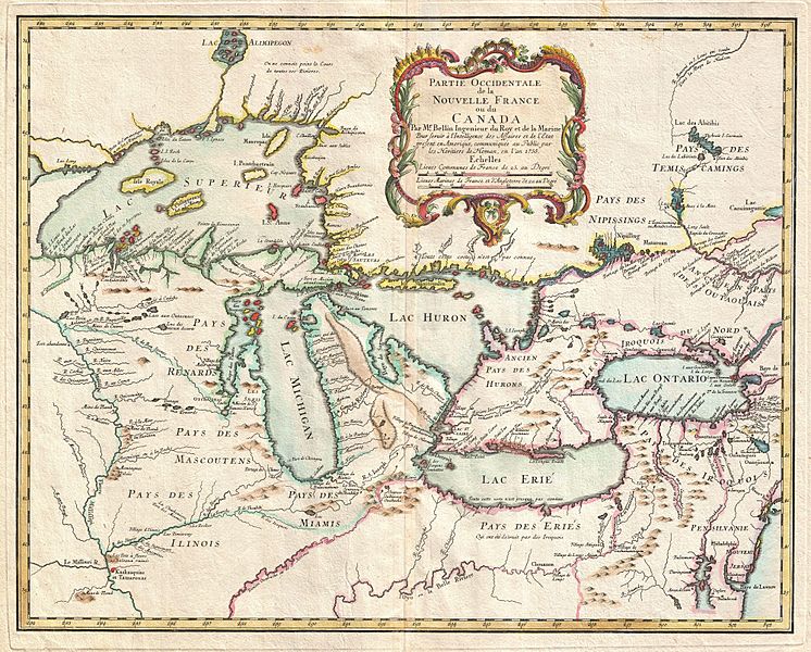
Description: A rare and extremely influential 1755 map of the Great Lakes drawn by Jacques Nicholas Bellin. This map, which appeared in the 1755 issue of the Homann Heirs Atlas Major , covers all five of the Great Lakes as well as the adjacent Indian lands and the English colonies of Pennsylvania, New Jersey and New York. Cartographically this map offers a number of important innovations and is largely derived from Bellin’s very similar map of 1745. The plate was acquired and reissued by Homann Heirs in 1755 in response to European interest in the French and Indian War which started one year prior in 1754. Bellin based this map on the most advanced French cartographic intelligence available at the time. Heidenrich and Dahl consider this map to constitute “the first new material pertaining to New France to appear since the maps of Guillaume de L'Isle three decades earlier. Most notably this map incorporates the work of the French fur trader and explorer Sieur la Verendrye and the explorer-missionary Father Pierre de Charlevoix. From Verendrye , Bellin is able to extract a significantly advanced view, over De L’Isle, of the form of the Great Lakes and their client river systems. He also relies on Verendrye’s journals with regard to the placement of numerous Indian nations and villages. Charlevoix is generally regarded as Bellin’s source for his curious choice to include several fictional islands in Lake Superior, including I. Philippeaux, I. Pontchartrain, and I. St. Anne. This map is the first, though hardly the last, to depict these ghost islands which baffled explorers until the early 19th century. A quick overview of this map will reveal a territory that is very much dominated by various American Indian nations though nominally under a tenuous French hegemony. The vast lands of the Miami, the Iroquois, the Erie, the Huron, the Renard, the Mascouten, and the Illinois overwhelm tiny bastions of French power in the form of various forts and missions. Among these are Fort Frontenac, Fort Niagara, Mission Francois Xavier, and the fledgling “R. et Port de Checagou,” the future site of Chicago. The French, without the vast colonial resources of the English and Spanish, relied heavily on alliance with, rather than outright control of, indigenous populations. Thus it is understandable why the American Indian nations of this region were quick to throw their lot in with the French against the domineering English during the French and Indian War. In the lower right hand quadrants of this map Bellin employs a common cartographic trick to flatter his royal patrons in Paris. By diminishing the proportional size of the English colonial holdings in Pennsylvania, New Jersey, Virginia and New York, Bellin, at least metaphorically, advances the supremacy of the French dominions in North America. In addition to its advanced mapping of the Great Lakes, its introduction of the ghost islands of Lake Superior, and its incorporation of the most recent explorations in the region, this map enjoys lasting significance due to John Mitchell’s use of it in compiling his important wall map, A Map of the British & French Dominions in North America . Mitchell’s monumental cartographic masterpiece was used in 1783 to define the boundaries between Canada and the post-Revolutionary United States, forming the basis for national borders that are still in effect today.
Title: Partie Occidentale de la Nouvelle France ou du Canada.
Credit: Atlas Homannianus Mathematic-Historice Delineatus, (Homann Heirs, Nuremburg), 1755. This file was provided to Wikimedia Commons by Geographicus Rare Antique Maps, a specialist dealer in rare maps and other cartography of the 15th, 16th, 17th, 18th and 19th centuries, as part of a cooperation project. Deutsch | English | français | македонски | Nederlands | polski | +/−
Author: Jacques-Nicolas Bellin
Permission: This is a faithful photographic reproduction of a two-dimensional, public domain work of art. The work of art itself is in the public domain for the following reason: This work is in the public domain in its country of origin and other countries and areas where the copyright term is the author's life plus 100 years or less. You must also include a United States public domain tag to indicate why this work is in the public domain in the United States. This file has been identified as being free of known restrictions under copyright law, including all related and neighboring rights. The official position taken by the Wikimedia Foundation is that "faithful reproductions of two-dimensional public domain works of art are public domain". This photographic reproduction is therefore also considered to be in the public domain in the United States. In other jurisdictions, re-use of this content may be restricted; see Reuse of PD-Art photographs for details.
Usage Terms: Public domain
License: Public domain
Attribution Required?: No
Image usage
The following 5 pages link to this image:
