
Image: 1823 Melish Map of the United States of America - Geographicus - USA-melish-1822
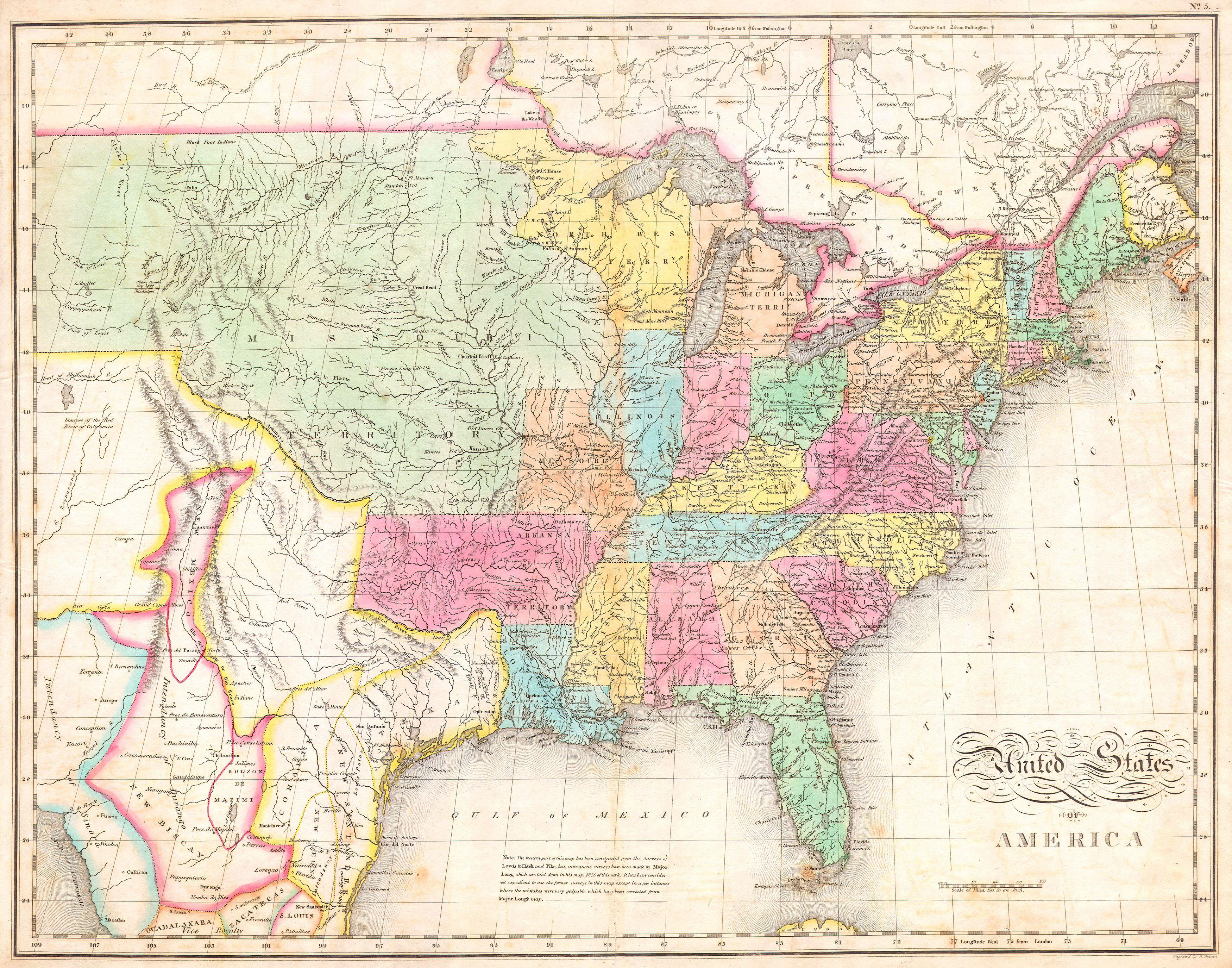
Description: One of the most important American maps of the United States to appear in the early 19th century. Depicts the United States and Mexico roughly from the Atlantic to the region immediately west of the Rocky Mountains, including the massive Missouri Territory, Texas and parts of Mexico. This map was produced by the joint efforts of three important American mapmakers: John Melish, Benjamin Tanner, and Mathew Cary. It had its origins in Melish’s 1812 pocket format map of the United States. Over the following fifteen years the map would be updated, revised, and improved for various reissues. The current example is from Carey and Lea’s Atlas . Referencing the cartographic and exploratory work of Lewis and Clark, Pike, and Major Long, this map attempted to give an accurate picture of the western United States. Shows both the newly formed state of Missouri and the massive Missouri Territory. This extraordinary tract of land extended form the Mississippi River westward off the edge of the map. In a seminal move that would later define the boundaries between the United States and New Spain, Melish delineated the 100th meridian as the border between Mexico ( Texas ) and the United States. Heading east, the border continued south along the Arkansas River and then eastward along the Red River Valley. The Arkansas Territory extended westward as far as Texas including the territory claimed by the modern day state of Oklahoma. On the eastern side of the Mississippi we see a large Northwest Territory bounded by Michigan on the east and Illinois on the south. The part of Michigan Territory on the western side of Lake Michigan is shown extending southward as far as the Illinois border. Virginia remains undivided. South of the border, in Mexico and Texas, New Mexico is shown as a sliver of land, containing Taos and Santa Fe, extending along the Rio Bravo (Rio del Norte) into the Intendency of Durango. Texas place names include Mesa, Loredo, San Saba, San Antonio, Pres del Alter, Ft. Matagorda, Nacagdoches, Panee Village, Cardo Village, Haytones, and Galvezton (Galveston) well inland on the Rio de Nieves or Neches. Apache Indians shown in Big Bend country. The map as a whole features excellent detail regarding mountain ranges and river valleys. Attempts with some success to place the various American Indian tribes as well as forts and cities. Also includes explorer’s notes, mostly referencing Louis and Clark, in the Missouri Territory. All in all, one of the most important maps of the United States published and a must for any serious Texas or Transmississippi collection. This map was published for inclusion as plate no. 5 in the 1823 issue of M. Cary and C. V. Lavoisne’s A Complete Genealogical, Historical, Chronological, and Geographical Atlas .
Title: United States of America
Credit: This file was provided to Wikimedia Commons by Geographicus Rare Antique Maps, a specialist dealer in rare maps and other cartography of the 15th, 16th, 17th, 18th and 19th centuries, as part of a cooperation project.
Author: John Melish
Permission: This is a faithful photographic reproduction of a two-dimensional, public domain work of art. The work of art itself is in the public domain for the following reason: Public domainPublic domainfalsefalse This work is in the public domain in its country of origin and other countries and areas where the copyright term is the author's life plus 100 years or fewer. You must also include a United States public domain tag to indicate why this work is in the public domain in the United States. This file has been identified as being free of known restrictions under copyright law, including all related and neighboring rights. https://creativecommons.org/publicdomain/mark/1.0/PDMCreative Commons Public Domain Mark 1.0falsefalse The official position taken by the Wikimedia Foundation is that "faithful reproductions of two-dimensional public domain works of art are public domain". This photographic reproduction is therefore also considered to be in the public domain in the United States. In other jurisdictions, re-use of this content may be restricted; see Reuse of PD-Art photographs for details.
Usage Terms: Public domain
License: Public domain
Attribution Required?: No
Image usage
There are no pages that link to this image.
