
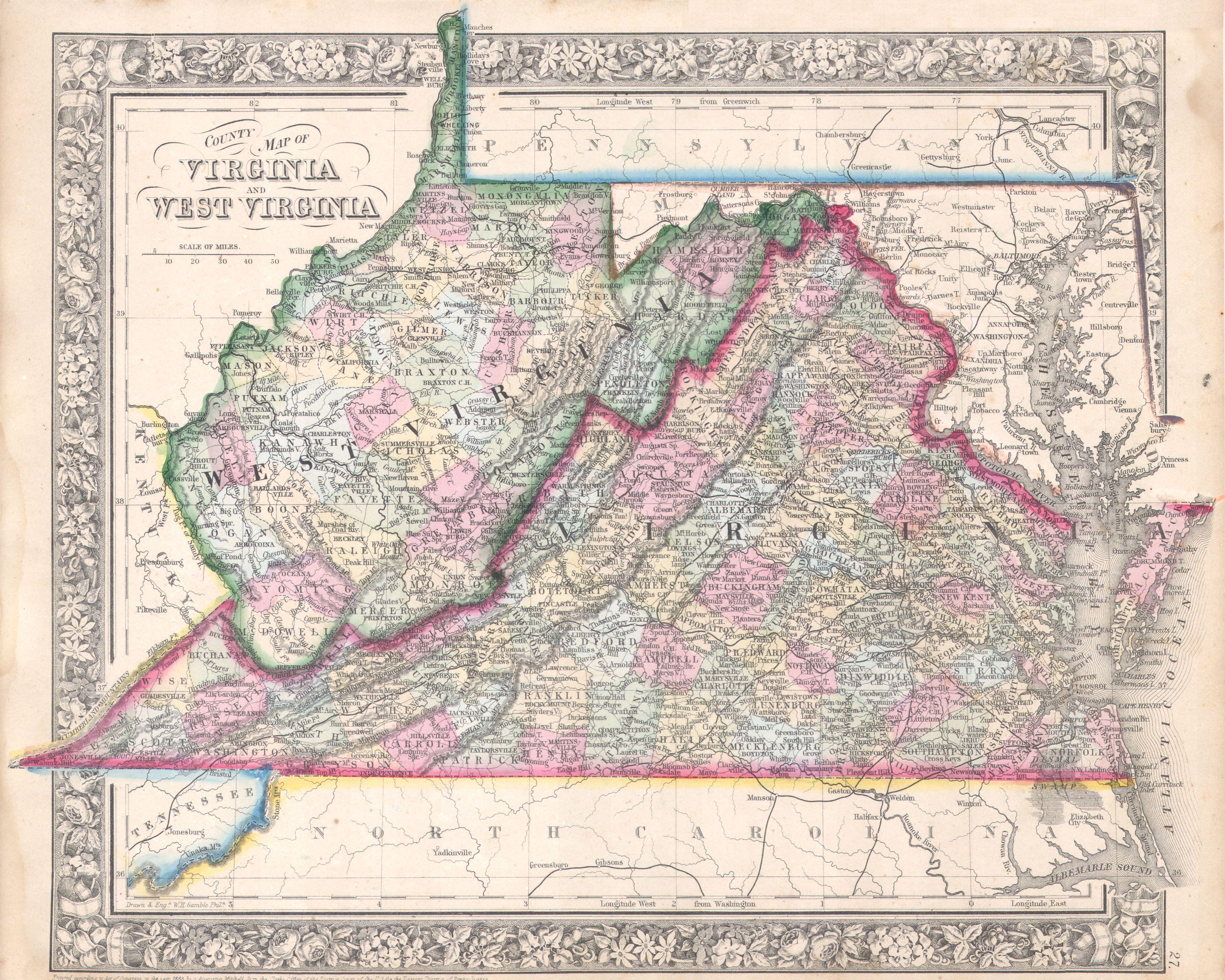
Image: 1864 Mitchell Map of Virginia, West Virginia, and Maryland - Geographicus - VAWV-mitchell-1864
Description: A beautiful example of S. A. Mitchell Jr.’s 1864 map of Virginia, West Virginia and Maryland. This map was revised version of Mitchells 1860 map of the same region to accommodate for the separation of Virginia and West Virginia in 1862. Includes the full Chesapeake Bay from Cape Henry to the mouth of the Susquehanna River. Curiously Harper’s Ferry is mapped into Virginia rather than West Virginia. Shortly after the end of the Civil War, Harpers Ferry, along with all of both Berkeley and Jefferson Counties, was separated from Virginia and incorporated into West Virginia. . The inhabitants of the counties as well as the Virginia legislature protested and is this that protest we see reflected here in Mitchell’s political map making. In the end the cartography was not to have his way and Harper’s Ferry was moved to West Virginia in subsequent maps, thus creating the West Virginia panhandle. One of the most attractive and interesting atlas maps of this region to appear in the mid 19th century. Features the floral border typical of Mitchell maps from the 1860-65 period. Prepared by W. H. Gamble for inclusion as plate 27 in the 1864 issue of Mitchell’s New General Atlas . Dated and copyrighted, “Entered according to Act of Congress in the Year 1863 by S. Augustus Mitchell Jr. in the Clerk’s Office of the District Court of the U.S. for the Eastern District of Pennsylvania.
Title: County Map of Virginia and West Virginia
Credit: Mitchell's New General Atlas, containing Maps of the Various Countries of the World, Plans of Cities, Etc., Embraced in Fifty-three Quarto Maps, forming a series of Eighty-Four Map and Plans, together with Valuable Statistical Tables. (1864 Edition) This file was provided to Wikimedia Commons by Geographicus Rare Antique Maps, a specialist dealer in rare maps and other cartography of the 15th, 16th, 17th, 18th and 19th centuries, as part of a cooperation project. Deutsch | English | français | македонски | Nederlands | polski | +/−
Author: Samuel Augustus Mitchell
Permission: This is a faithful photographic reproduction of a two-dimensional, public domain work of art. The work of art itself is in the public domain for the following reason: This work is in the public domain in its country of origin and other countries and areas where the copyright term is the author's life plus 100 years or less. You must also include a United States public domain tag to indicate why this work is in the public domain in the United States. This file has been identified as being free of known restrictions under copyright law, including all related and neighboring rights. The official position taken by the Wikimedia Foundation is that "faithful reproductions of two-dimensional public domain works of art are public domain". This photographic reproduction is therefore also considered to be in the public domain in the United States. In other jurisdictions, re-use of this content may be restricted; see Reuse of PD-Art photographs for details.
Usage Terms: Public domain
License: Public domain
Attribution Required?: No
Image usage
The following 2 pages link to this image:
