
Image: 1869 U.S. Coast Survey Map of the San Francisco Peninsula - Geographicus - SanFranciscoPeninsula2-uscs-1869
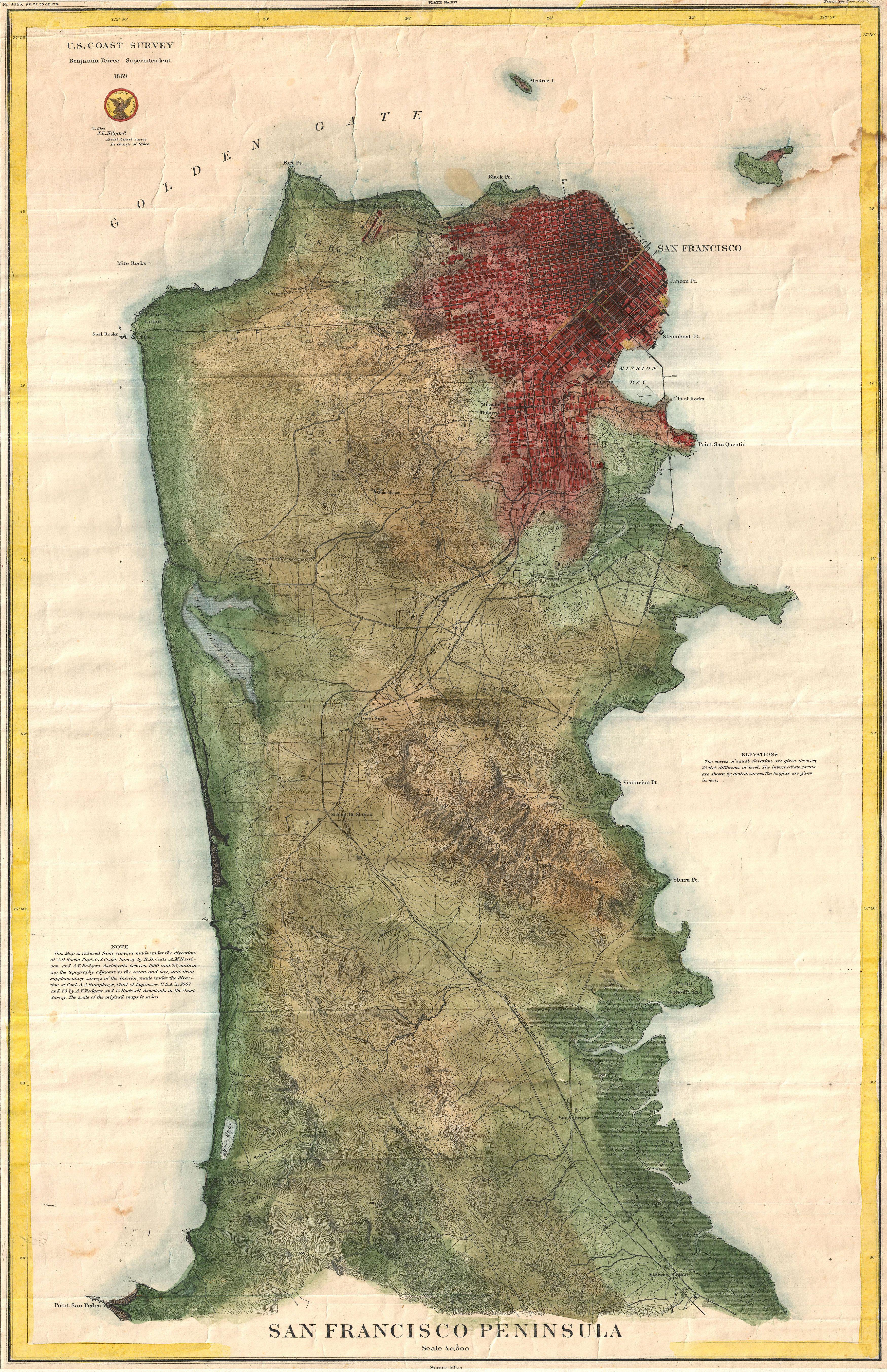
Description: A rare 1869 U.S. Coast Survey chart or map of San Francisco Peninsula. This map depicts the city of San Francisco and surrounding areas as far south as San Pedro and Millbrae Station. The San Francisco – San Jose Railroad, the first to link the port of San Francisco to the major inland rail yards in San Jose, is clearly noted. This island Alcatraz is also noted with some of its early military fortifications evident. This chart is of significance not only for its stunning detailed mapping of the San Francisco Peninsula, but also because it is one of the first U.S. Coast Survey charts use contour lines to depict topography. The convention would, in subsequent years be adopted by the U.S. Geological Survey – a late 19th century offshoot of the U.S. Coast Survey. This stunning example of the Coast Survey’s work at its finest was completed under the supervision of A. D. Bache by R. D. Cutts, A. M Harrison, and A. F. Rodgers between 1850 and 1857. It is of note that this example of the maps was not issued as part of the U.S. Coast Survey Annual Report, but rather is an independent issued chart on thick stock.
Title: San Francisco Peninsula
Credit: This file was provided to Wikimedia Commons by Geographicus Rare Antique Maps, a specialist dealer in rare maps and other cartography of the 15th, 16th, 17th, 18th and 19th centuries, as part of a cooperation project. Deutsch | English | français | македонски | Nederlands | polski | +/−
Author: United States Coast Survey
Permission: This is a faithful photographic reproduction of a two-dimensional, public domain work of art. The work of art itself is in the public domain for the following reason: This work is in the public domain in its country of origin and other countries and areas where the copyright term is the author's life plus 70 years or less. You must also include a United States public domain tag to indicate why this work is in the public domain in the United States. Note that a few countries have copyright terms longer than 70 years: Mexico has 100 years, Jamaica has 95 years, Colombia has 80 years, and Guatemala and Samoa have 75 years. This image may not be in the public domain in these countries, which moreover do not implement the rule of the shorter term. Côte d'Ivoire has a general copyright term of 99 years and Honduras has 75 years, but they do implement the rule of the shorter term. Copyright may extend on works created by French who died for France in World War II (more information), Russians who served in the Eastern Front of World War II (known as the Great Patriotic War in Russia) and posthumously rehabilitated victims of Soviet repressions (more information). This file has been identified as being free of known restrictions under copyright law, including all related and neighboring rights. The official position taken by the Wikimedia Foundation is that "faithful reproductions of two-dimensional public domain works of art are public domain". This photographic reproduction is therefore also considered to be in the public domain in the United States. In other jurisdictions, re-use of this content may be restricted; see Reuse of PD-Art photographs for details. Template:PD-Art template without license parameter: please specify why the underlying work is public domain in both the source country and the United States (Usage: Template:PD-Art, where parameter #1 can be PD-old-auto, PD-old-auto-1923, PD-old-auto-1996, PD-old-100 or similar. See Commons:Multi-license copyright tags for more information.)
Usage Terms: Public domain
License: Public domain
Attribution Required?: No
Image usage
The following page links to this image:
