
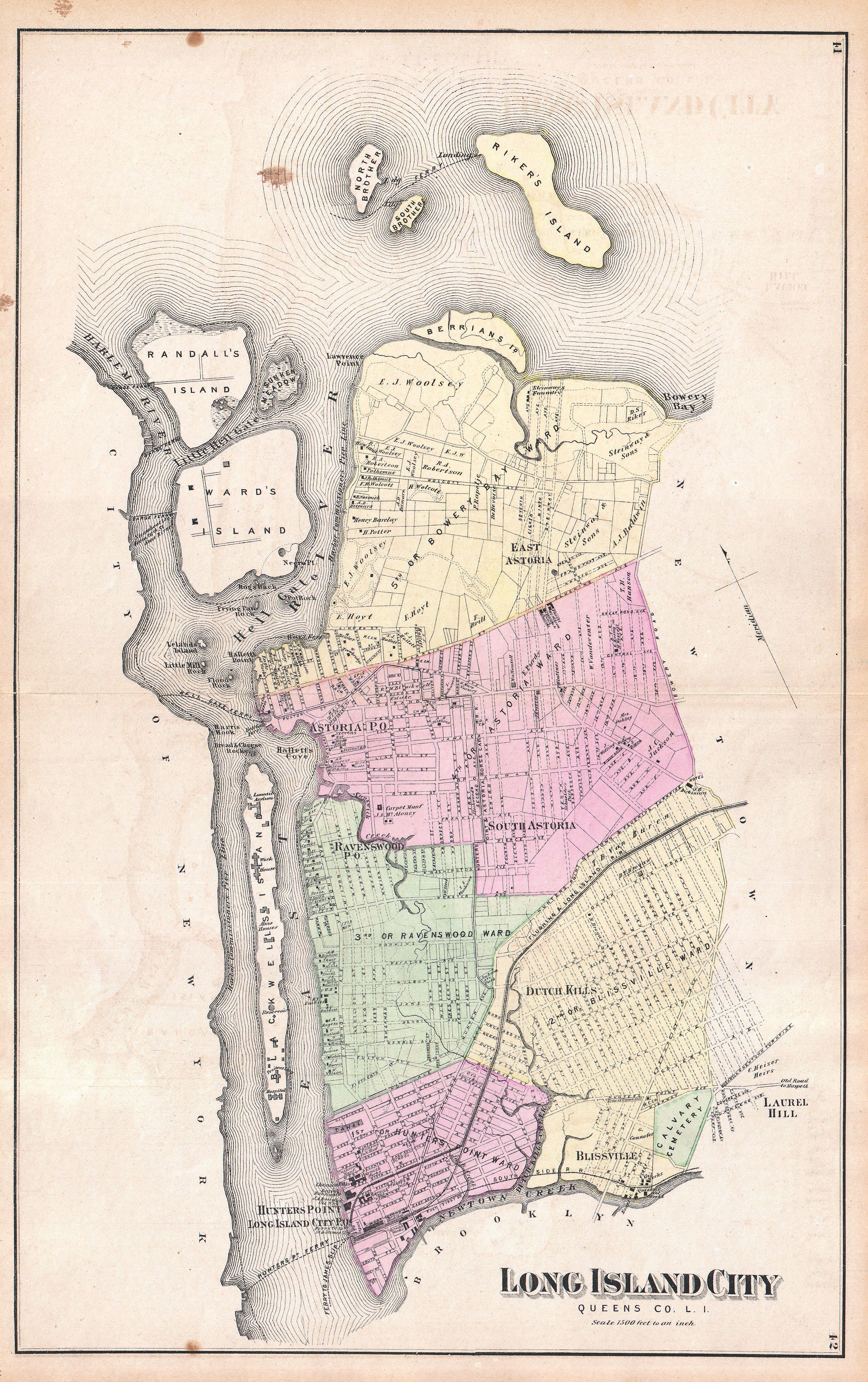
Image: 1873 Beers Map of Astoria and Long Island City, Queens, New York - Geographicus - LongIslandCity-beers-1873
Description: A scarce example of Fredrick W. Beers’ map of the Long Island City, Queens, New York. Published in 1873. Covers from Hunters Point and Long Island City northward past Ravenswood and Dutch Kills to include all of Astoria. Also includes Blackwell’s Island (Roosevelt Island), Hells Gate, Ward’s Island, Randall’s Island, and Riker’s Island. Detailed to the level of individual streets and important buildings. Lists estates and properties in Astoria. Notates ferry crossings between Long Island City and Astoria and the various Islands, including Manhattan. Detailed plans of Dutch Kills and Blissville on verso. This is probably the finest atlas map of Astoria and Long Island City, Queens to appear in the 19th century. Prepared by Beers, Comstock & Cline out of their office at 36 Vesey Street, New York City, for inclusion in the first published atlas of Long Island, the 1873 issue of Atlas of Long Island, New York.
Title: Long Island City, Queens Co.L.I.
Credit: This file was provided to Wikimedia Commons by Geographicus Rare Antique Maps, a specialist dealer in rare maps and other cartography of the 15th, 16th, 17th, 18th and 19th centuries, as part of a cooperation project.
Author: http://www.geographicus.com/mm5/cartographers/beers.txt
Permission: This is a faithful photographic reproduction of a two-dimensional, public domain work of art. The work of art itself is in the public domain for the following reason: Public domainPublic domainfalsefalse This work is in the public domain in its country of origin and other countries and areas where the copyright term is the author's life plus 70 years or fewer. You must also include a United States public domain tag to indicate why this work is in the public domain in the United States. Note that a few countries have copyright terms longer than 70 years: Mexico has 100 years, Jamaica has 95 years, Colombia has 80 years, and Guatemala and Samoa have 75 years. This image may not be in the public domain in these countries, which moreover do not implement the rule of the shorter term. Côte d'Ivoire has a general copyright term of 99 years and Honduras has 75 years, but they do implement the rule of the shorter term. Copyright may extend on works created by French who died for France in World War II (more information), Russians who served in the Eastern Front of World War II (known as the Great Patriotic War in Russia) and posthumously rehabilitated victims of Soviet repressions (more information). This file has been identified as being free of known restrictions under copyright law, including all related and neighboring rights. https://creativecommons.org/publicdomain/mark/1.0/PDMCreative Commons Public Domain Mark 1.0falsefalse The official position taken by the Wikimedia Foundation is that "faithful reproductions of two-dimensional public domain works of art are public domain". This photographic reproduction is therefore also considered to be in the public domain in the United States. In other jurisdictions, re-use of this content may be restricted; see Reuse of PD-Art photographs for details. Template:PD-Art template without license parameter: please specify why the underlying work is public domain in both the source country and the United States (Usage: Template:PD-Art, where parameter #1 can be PD-old-auto, PD-old-auto-expired, PD-old-auto-1996, PD-old-100 or similar. See Commons:Multi-license copyright tags for more information.)
Usage Terms: Public domain
License: Public domain
Attribution Required?: No
Image usage
The following 2 pages link to this image:
