
Image: 1886 Sanborn Fire Insurance Map - Church Square - Davenport, Iowa

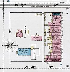
Description: An 1886 Sanborn Fire Insurance Map cropped to show Church Square in Davenport, Iowa, United States. St. Anthony's Church (blue) is lower left (note the rear addition is not complete). The rectory (above left) and the school (original church) behind it are in pink. On the east side of the property along Brady Street (right) are commercial buildings.
Title: 1886 Sanborn Fire Insurance Map - Church Square - Davenport, Iowa
Credit: File:Sanborn_Fire_Insurance_Map_from_Davenport,_Scott_County,_Iowa._LOC_sanborn02624_001-14.jpg
Author: Unknown authorUnknown author
Permission: This map is available from the United States Library of Congress's Geography & Map Division under the digital ID g4154dm.g026241886. This tag does not indicate the copyright status of the attached work. A normal copyright tag is still required. See Commons:Licensing for more information.
Usage Terms: Public domain
License: Public domain
Attribution Required?: No
Image usage
The following page links to this image:
