
Image: Alnmouth Tithe Map 1843

Size of this preview: 383 × 600 pixels. Other resolutions: 153 × 240 pixels | 954 × 1,494 pixels.
Original image (954 × 1,494 pixels, file size: 2.54 MB, MIME type: image/png)
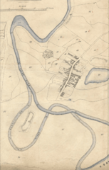
Description: Tithe map of Alnmouth, Northumberland, 1843, showing in particular the changed course of the River Aln after a storm in 1806 knocked out an oxbow meander.
Title: Alnmouth Tithe Map 1843
Credit: Historic Environment Survey for the National Trust Properties on the Northumberland Coast Buston Links, Alnmouth Prepared for the National Trust July 2009 Report No: 0058/1-09
Author: Report authors: Archaeo-Environment Ltd Marian Cottage Lartington Barnard Castle County Durham DL12 9BP Tithe map dates to 1843, is used in the report, but was not originated by A-E Ltd.
Usage Terms: Public domain
License: Public domain
Attribution Required?: No
Image usage
The following 3 pages link to this image:

All content from Kiddle encyclopedia articles (including the article images and facts) can be freely used under Attribution-ShareAlike license, unless stated otherwise.