
Image: Anahim Volcanic Belt-en

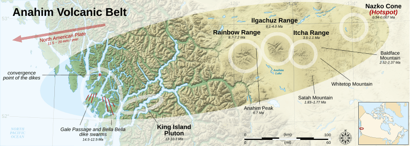
Description: Map of the Anahim Volcanic Belt, a range of volcanoes in British Columbia, Canada.
Title: Anahim Volcanic Belt-en
Credit: Own work. Data sources: Background map: data from NASA Shuttle Radar Topography Mission (SRTM3 v.2 & SWDB) (public domain), and from the paper Catalogue of Canadian volcanoes (Natural Resources Canada) on page 35 Locator map made from Canada_(geolocalisation).svg created by STyx under GFDL & CC-BY-SA-2.5 ; compass rose from Compass rose pale.svg (opacified) created by Fibonacci under GFDL ; scale from Image:Scale_kilometres_miles_svg.svg by Sémhur under GFDL & CC-BY-SA-3.0. Note: the North American plate velocity is between 1.15 and 2 cm/years, depending on several sources. Softwares used: NASA datas edited with Global Mapper 9 (limited version) by the United States Geological Survey (USGS) and 3DEM from Visualization Software LLC Vectorized with Inkscape The Gimp Others: UTM map projection WGS84 geodetic system Shaded relief (ligth direction) : altitude 61°, azimuth 315°, ambient Light 0.10, vertical exaggeration : 0.8 Fonts: Arial and Times New Roman
Author: Sémhur (talk)
Usage Terms: Creative Commons Attribution-Share Alike 4.0
License: CC BY-SA 4.0
License Link: https://creativecommons.org/licenses/by-sa/4.0
Attribution Required?: Yes
Image usage
The following 4 pages link to this image:
