
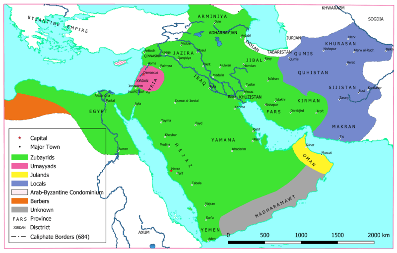
Image: Approximate map of areas under Ibn al-Zubayr's control after the death of Muawiya II

Description: Approximate map of areas under Ibn al-Zubayr's control after the death of Muawiya II.
Title: Approximate map of areas under Ibn al-Zubayr's control after the death of Muawiya II
Credit: Own work. Base map: [1]; Caliphate Borders: [2][3][4]; Locations: [2][3][4]; Provincial borders (modified as per Control): [2][3][5]; Control:[6][7][8][9][10] [1] Demis World Map Server. [2] Robinson, C. F. (ed.) (2011) The New Cambridge History of Islam, Vol 1. Maps 3–9. [3] Kennedy, H. N. (ed.) Historical Atlas of Islam. Brill. [4] Al Ameer son. File:Second Fitna Territorial Control Map ca 686.png. [5] Malise Ruthven, Azim Nanji (2004) - Historical Atlas of Islam. Harvard University Press. p. 29. [6] Donner, F. M. (2010). Muhammad and the Believers, at the Origins of Islam. Harvard University Press. pp. 181–182. [7] Hawting, G. R. (1989) Tabari. Vol 20. SUNY press. pp. 49–51. [8] Hawting, G. R. (2000). The First Dynasty of Islam: The Umayyad Caliphate AD 661–750. Routledge. p. 48. [9] Gibb, H. A. R. (1960). "ʿAbd Allāh ibn al-Zubayr". In EI2. Vol 1. p. 55. [10] Rotter, Gernot (1982). Die Umayyaden und der zweite Bürgerkrieg (680–692) (in German). Wiesbaden: Deutsche Morgenländische Gesellschaft. p. 84.
Author: AhmadLX
Usage Terms: Creative Commons Attribution-Share Alike 4.0
License: CC BY-SA 4.0
License Link: https://creativecommons.org/licenses/by-sa/4.0
Attribution Required?: Yes
Image usage
The following page links to this image:
