
Image: Auckland.arp.750pix

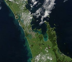
Description: Auckland area, showing the base of the Northland Peninsula (top left), Auckland city (centre left), the Waikato plains (lower left), the Hauraki Gulf (centre), Coromandel Peninsula (right of centre), and the western Bay of Plenty and city of Tauranga (lower right). "This stunning true-color image provides a rare, cloud-free look at the island nation of New Zealand, including most of its North and South Islands. This scene was acquired by the Moderate Resolution Imaging Spectroradiometer (MODIS), flying aboard NASA’s Terra satellite, on October 23, 2002. New Zealand is situated in the South Pacific Ocean, roughly 2,000 km (1,250 miles) southeast of Australia. Wellington, the capital of New Zealand, is located on the southern tip of the North Island, looking across Cook Strait toward South Island."
Title: Auckland.arp.750pix
Credit: https://lance-modis.eosdis.nasa.gov/cgi-bin/imagery/single.cgi?image=NewZealand.A2002296.2220.250m.jpg (image link); see also https://earthobservatory.nasa.gov/images/3101/new-zealand and https://visibleearth.nasa.gov/view.php?id=62892
Author: NASA/GSFC/MODIS Land Rapid Response Team, Jacques Descloitres
Usage Terms: Public domain
License: Public domain
Attribution Required?: No
Image usage
The following page links to this image:
