
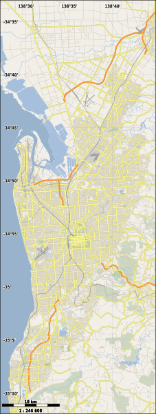
Image: Australia Greater Adelaide location map

Size of this PNG preview of this SVG file: 227 × 599 pixels. Other resolution: 91 × 240 pixels.
Original image (SVG file, nominally 437 × 1,154 pixels, file size: 4.18 MB)
Description: Location map of Greater Adelaide, Australia. Bounding coordinates are top = -34.55, bottom = -35.20, left = 138.45, right = 138.75
Title: Australia Greater Adelaide location map
Credit: Transferred from en.wikipedia to Commons.
Author: Created by User:ScottDavis using Maperitive from Open Street Map data
Usage Terms: Creative Commons Attribution-Share Alike 2.0
License: CC BY-SA 2.0
License Link: https://creativecommons.org/licenses/by-sa/2.0
Attribution Required?: Yes
Image usage
The following 13 pages link to this image:
- Bolivar, South Australia
- Crafers, South Australia
- Ethelton, South Australia
- Evandale, South Australia
- Garden Island (South Australia)
- Gawler, South Australia
- Glenunga, South Australia
- Happy Valley Reservoir
- Hove, South Australia
- Marino, South Australia
- Para Vista, South Australia
- Parafield, South Australia
- Parafield Airport

All content from Kiddle encyclopedia articles (including the article images and facts) can be freely used under Attribution-ShareAlike license, unless stated otherwise.