
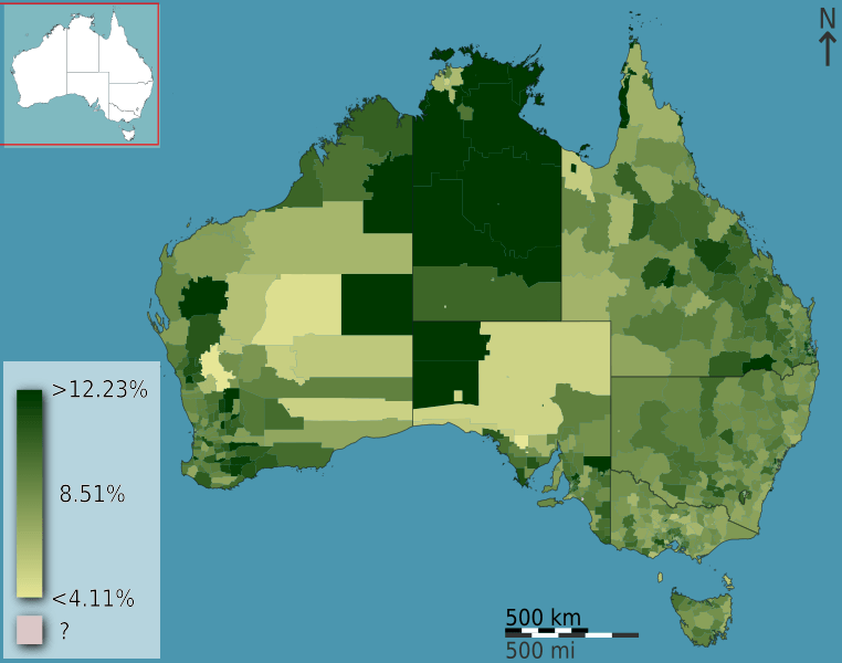
Image: Australian Census 2011 demographic map - Australia by SLA - BCP field 2817 Infants Primary Total Persons

Description: People attending an infants or primary school as a fraction of total persons, in Australia, Australia, according to the 2011 census results. The map is divided into geographical subdivisions by Statistical Local Area. Note the split scale above and below the median value.
Title: Australian Census 2011 demographic map - Australia by SLA - BCP field 2817 Infants Primary Total Persons
Credit: Own work This image is based on data from the Australian 2011 Census of Population and Housing compiled by the Australian Bureau of Statistics. The data plotted is from the Basic Community Profile, field 2817 entitled "Infants Primary Total Persons". The raw data is made available as part of datapacks (download details) and is licensed under the Creative Commons Attribution 2.5 license (Australia). English | +/−
Author: Toby Hudson based on data from the Australian Bureau of Statistics
Usage Terms: Creative Commons Attribution-Share Alike 3.0 au
License: CC BY-SA 3.0 au
License Link: http://creativecommons.org/licenses/by-sa/3.0/au/deed.en
Attribution Required?: Yes
Image usage
There are no pages that link to this image.
