
Image: BURBANKAerial2022

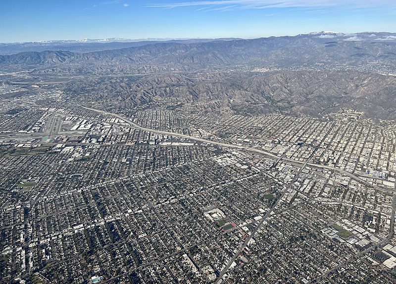
Description: An aerial view of Burbank, CA. In this photo looking north, Hollywood Burbank Airport can be seen on the far left. Interstate 5 Freeway can be seen separating Burbank's halves. The Verdugo Mountains can be seen above Burbank's foothill communities (primarily residential). Notably, the 456,000 sq ft Ikea in Burbank (building in bright blue and yellow), which is the largest in North America, can be seen on the right side of the picture. John Burroughs High School can be seen in the right foreground. The main thoroughfares of Olive Avenue, Verdugo Avenue, Magnolia Boulevard, Burbank Boulevard, and Victory Boulevard can be seen in the picture. Buena Vista Street and Hollywood Way can also be seen intersecting the major streets. The Burbank Empire Center can be seen along the 5 Fwy, which marks where the former Lockheed Corp. site was up until 1990. Downtown Burbank can be seen to the east of the 5 Fwy. Snowcapped mountains can be seen in the far background. A small pocket of Sun Valley (part of the City of Los Angeles) can be seen to the left of Burbank Airport.
Title: BURBANKAerial2022
Credit: Own work
Author: Platinummedia
Usage Terms: Creative Commons Attribution-Share Alike 4.0
License: CC BY-SA 4.0
License Link: https://creativecommons.org/licenses/by-sa/4.0
Attribution Required?: Yes
Image usage
The following page links to this image:
