
Image: Belgian Medieval Dioceses

Size of this preview: 437 × 600 pixels. Other resolutions: 175 × 240 pixels | 1,664 × 2,284 pixels.
Original image (1,664 × 2,284 pixels, file size: 140 KB, MIME type: image/png)
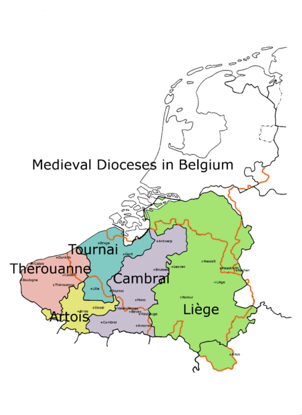
Description: This is a map showing the old Catholic dioceses, which were to some extent based upon ancient Roman and pre-Roman territories.
Title: Belgian Medieval Dioceses
Credit: Using Gimp software Previously published: Various old Belgian books, Kleine atlas voor de geschiedenis van beide Limburgen. J.H.M. Wieland, page 15 Kerkelijke indeling van de Nederlanden
Author: Andrew Lancaster
Usage Terms: Creative Commons Attribution-Share Alike 3.0
License: CC BY-SA 3.0
License Link: http://creativecommons.org/licenses/by-sa/3.0
Attribution Required?: Yes
Image usage
The following page links to this image:

All content from Kiddle encyclopedia articles (including the article images and facts) can be freely used under Attribution-ShareAlike license, unless stated otherwise.