
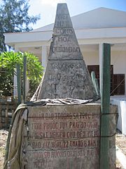
Image: Bia VNCH Truong Sa - Republic of Vietnam Spratly Islands Territorial Marker

Size of this preview: 450 × 600 pixels. Other resolutions: 180 × 240 pixels | 1,704 × 2,272 pixels.
Original image (1,704 × 2,272 pixels, file size: 1.07 MB, MIME type: image/jpeg)
Description: Territorial monument of the Republic of Vietnam (South Vietnam) on Southwest Cay, Spratly Islands, defining the cay as part of Vietnamese territory (to Phước Tuy Province). Used since 22 August, 1956 until 1975, when replaced by another one from the Socialist Republic of Vietnam (successor)..
Title: Bia VNCH Truong Sa - Republic of Vietnam Spratly Islands Territorial Marker
Credit: Own work
Author: Phạm Xuân Nguyên
Usage Terms: Creative Commons Attribution-Share Alike 3.0
License: CC BY-SA 3.0
License Link: http://creativecommons.org/licenses/by-sa/3.0
Attribution Required?: Yes
Image usage
The following 2 pages link to this image:

All content from Kiddle encyclopedia articles (including the article images and facts) can be freely used under Attribution-ShareAlike license, unless stated otherwise.