
Image: Big Thomson Mesa, Capitol Reef National Park, Utah

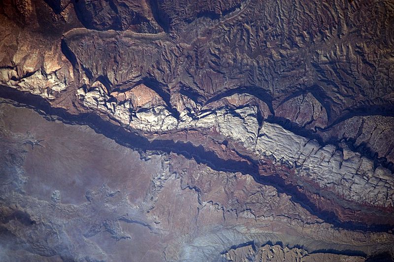
Description: This detailed astronaut photograph shows part of Big Thomson Mesa, near the southern end of Capitol Reef National Park. Capitol Reef National Park is located on the Colorado Plateau, which occupies the adjacent quarters of Arizona, Colorado, New Mexico, and Utah. Big Thomson Mesa (image left) is part of a large feature known as the en:Waterpocket Fold. The Fold is a geologic structure called a monocline—layers of generally flat-lying sedimentary rock with a steep, one-sided bend, like a carpet runner draped over a stair step. Geologists think that monoclines on the Colorado Plateau result from faulting (cracking) of deeper and more brittle crystalline rocks under tectonic pressure; while the crystalline rocks were broken into raised or lowered blocks, the overlaying, less brittle sedimentary rocks were flexed without breaking. The portion of the Waterpocket Fold illustrated in this image includes layered rocks formed during the Mesozoic Era (about 250 – 65 million years ago). The oldest layers are at the bottom of the sequence, with each successive layer younger than the preceding one going upwards in the sequence. Not all of the formation’s rock layers are clearly visible, but some of the major layers (units to geologists) can be easily distinguished. The top half of the image includes the oldest rocks in the view: dark brown and dark green Moenkopi and Chinle Formations. Moving toward the foot of the mesa, two strikingly coloured units are visible near image centre: light red to orange Wingate Sandstone and white Navajo Sandstone. Beyond those units, reddish brown to brown Carmel Formation and Entrada Sandstone occupy a topographic bench at the foot of a cliff. The top of the cliff face above this bench—Big Thomson Mesa—is comprised of brown Dakota Sandstone. This sequence represents more than 100 million years of sediments being deposited and turned into rock. Much younger Quaternary (2-million- to approximately 10,000-year-old) deposits are also present in the view. The area shown in this astronaut photograph is located approximately 65 kilometers to the southeast of Fruita, UT near the southern end of Capitol Reef National Park.
Title: Big Thomson Mesa, Capitol Reef National Park, Utah
Credit: NASA Earth Observatory
Author: This image was taken by the NASA Expedition 20 crew
Usage Terms: Public domain
License: Public domain
Attribution Required?: No
Image usage
The following page links to this image:
