
Image: Black Moshannon SP Historic Districts Map
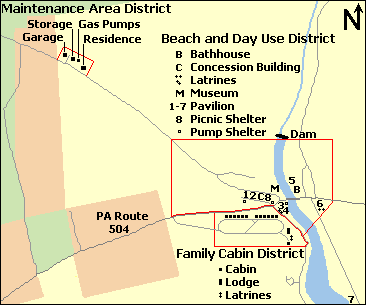
Description: Map of three Black Moshannon State Park Historic Districts, Centre County, Pennsylvania, USA
Title: Black Moshannon SP Historic Districts Map
Credit: water and roads taken from US Census website [1] and modified by User:Ruhrfisch, property boundaries based on this PennDOT map, facilities based on this PA DCNR map. Maintenance District information from NRHP nomination form, Family Cabin District information from NRHP nomination form, and Beach and Day Use District informaton from NRHP nomination form.
Author: US Census, Ruhrfisch
Permission: US Census / US Government work is public domain, my modifications licensed under the GNU Free Documentation License
Usage Terms: Public domain
License: Public domain
Attribution Required?: No
Image usage
The following 2 pages link to this image:
