
Image: Borders of Four Corners, USA survey years

Size of this PNG preview of this SVG file: 240 × 250 pixels. Other resolution: 230 × 240 pixels.
Original image (SVG file, nominally 240 × 250 pixels, file size: 63 KB)
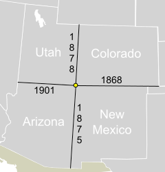
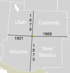
Description: A map showing the borders that make up Four Corners, United States. The years the borders were officially surveyed and marked are show.
Title: Borders of Four Corners, USA survey years
Credit: This file was derived from: Blank US Map.svg: author: User:Theshibboleth
Author: Mangoman88 (talk)
Usage Terms: Creative Commons Attribution-Share Alike 3.0
License: CC-BY-SA-3.0
License Link: http://creativecommons.org/licenses/by-sa/3.0/
Attribution Required?: Yes
Image usage
The following page links to this image:

All content from Kiddle encyclopedia articles (including the article images and facts) can be freely used under Attribution-ShareAlike license, unless stated otherwise.