
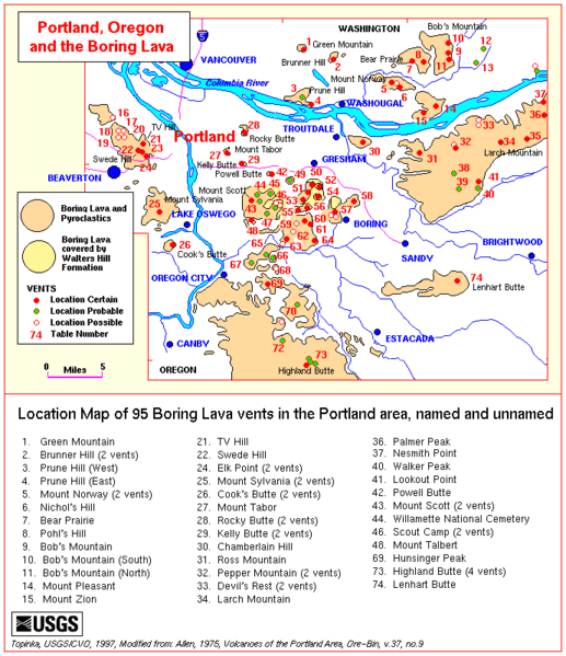
Image: Boring lava allen map

Description: Map of the Boring Lava Field in Oregon and southwest Washington Legend: 1. Green Mountain 2. Brunner Hill (2 vents) 3. Prune Hill (West) 4. Prune Hill (East) 5. Mount Norway (2 vents) 6. Nochol's Hill 7. Bear Prairie 8. Pohl's Mountain 9. Bob's Mountain (South) 10. Bob's Mountain (North) 14. Mount Pleasant 15. Mount Zion 21. TV Hill 22. Swede Hill 24. Elk Point (2 vents) 25. Mount Sylvania (2 vents) 26. Cook's Butte (2 vents) 27. Mount Tabor 28. Rocky Butte (2 vents) 29. Kelly Butte (2 vents) 30. Chamberlain Hill 31. Ross Mountain 32. Pepper Mountain (2 vents) 33. Devil's Rest (2 vents) 34. Larch Mountain 36. Palmer Peak 37. Nesmith Point 40. Walker Peak 41. Lookout Point 42. Powell Butte 43. Mount Scott (2 vents) 44. Willamette National Cemetery 46. Scout Camp (2 vents) 48. Mount Talbert 69. Hunsinger Peak 73. Highland Butte (4 vents) 74. Lenhart Butte
Title: Boring lava allen map
Credit: http://vulcan.wr.usgs.gov/Volcanoes/Oregon/Publications/Allen1975/boring_lava_allen_table.html
Author: Lyn Topinka; modified from: Allen, 1975, Volcanoes of the Portland Area, Ore-Bin, v.37, no. 9
Usage Terms: Public domain
License: Public domain
Attribution Required?: No
Image usage
The following 2 pages link to this image:
