
Image: Borough House Plantation (Stateburg, South Carolina)

Size of this preview: 800 × 561 pixels. Other resolutions: 320 × 224 pixels | 4,694 × 3,290 pixels.
Original image (4,694 × 3,290 pixels, file size: 3.41 MB, MIME type: image/jpeg)
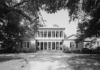
Description: Borough House Plantation — West Side State Route 261, about .1 mile south side of junction with old Garners Ferry Road, Stateburg, Sumter County, South Carolina. 1960 image: HABS—Historic American Buildings Survey of South Carolina (cropped).
Title: Borough House Plantation (Stateburg, South Carolina)
Credit: http://memory.loc.gov/cgi-bin/displayPhoto.pl?path=/pnp/habshaer/sc/sc0300/sc0358/photos&topImages=150974pr.jpg&topLinks=150974pv.jpg,150974pu.tif&title=7.%20%20May%201985.%20EAST%20(FRONT)%20FACADE%20IN%20SPRING%3cbr%3eHABS%20SC,43-STATBU,1-7&displayProfile=0
Author: Jack Boucher
Permission: Historic American Buildings Survey
Usage Terms: Public domain
License: Public domain
Attribution Required?: No
Image usage

All content from Kiddle encyclopedia articles (including the article images and facts) can be freely used under Attribution-ShareAlike license, unless stated otherwise.
.jpg)