
Image: Breakup of Yugoslavia

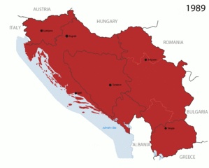
Description: This is an animated GIF that shows the stages of the breakup of the SFR Yugoslavia in the 90's and 2000's. The map based off Morwen's map of the divisions of the SFRY, Which is licensed by the GFDL. The source for the dates of independence is the CIA World Factbook. These maps do not now show the Inter-Entity Boundary Line (IEBL) and/or the entities that are separated by it. The IEBL has been drawn based on this CIA map; the Brčko District has been drawn based on Image:BH municipality location.gif, by user:Ante Perkovic. I might add them in the future. Since the original map was GFDL, this image is as well. A map depicting Kosovo's final status is ready once it takes effect. Changelog for versions 2/3: Here are some changes in this new build of the map: The Kosovo boundary has been given a shade of red instead of the previous UN blue since they are a province of Serbia under UNIMIK control. Montenegro's color has been changed to a golden shade close to what's on the flag. The IEBL and the Brčko District has been redrawn because I deleted the original map; the color for the Republika Srpska is lighter. The dates are at the top left hand corner of the map instead of the bottom. I have taken a new approach as to the boundaries. Each part of Yugoslavia now shows the boundary on the maps starting the year they broke away. I feel this change helps readers understand the breakup better. The SFRY and the FRY are in different shades since the FRY was never accepted as the successor to the former by the UN. The colors for the entities of BiH have been removed as to not confuse people into thinking that they are independent states. What remains is the IEBL with both entities in green. The Kosovo boundary is finally in hash marks! The Brčko District has been removed. The sale is too small to show accurately. Changelog for version 4: The map is larger! The image has been rebuilt to include the eastern part of FYR Macedonia. The image has been updated to take in Kosovo's new status. The IEBL is now a darker line. Montenegro, Kosovo, and FRY/SCG/Serbia have new colors! Changelog for version 5: Rebuilt Larger map: size of base image Accurate Inter-Entity Boundary Line
Title: Breakup of Yugoslavia
Credit: Made by Hoshie; see above for more details on sources.
Author: Hoshie
Usage Terms: Creative Commons Attribution-Share Alike 3.0
License: CC-BY-SA-3.0
License Link: http://creativecommons.org/licenses/by-sa/3.0/
Attribution Required?: Yes
Image usage
The following page links to this image:
