
Image: Bristolharbourmap
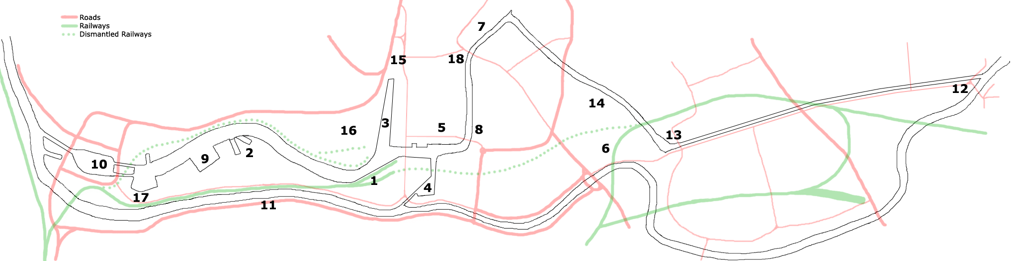
Description: For a key to this map, see 
- Prince's Wharf, including M Shed, Pyronaut and Mayflower adjoining Prince Street Bridge
- Dry docks: SS Great Britain, the Matthew
- St Augustine's Reach, Pero's Bridge
- Bathurst Basin
- Queen Square
- Bristol Temple Meads railway station
- Castle Park
- Redcliffe Quay and Redcliffe Caves
- Baltic Wharf marina
- Cumberland Basin & Brunel Locks
- The New Cut
- Netham Lock, entrance to the Feeder Canal
- Totterdown Basin
- Temple Quay
- The Centre
- Canons Marsh, including Millennium Square and At-Bristol
- Underfall Yard
- Bristol Bridge
for a simple way to embed both the image and key. Prince's Wharf, including the Bristol Industrial Museum, Pyronaut Dry docks: SS Great Britain, The Matthew St Augustine's Reach, Pero's Bridge Bathurst Basin Queen Square Bristol Temple Meads railway station Castle Park Redcliffe Quay and Redcliffe Caves Baltic Wharf marina Cumberland Basin & Brunel Locks The New Cut Netham Lock, entrance to the Feeder Canal Totterdown Basin Temple Quay St Augustine's Parade Canons Marsh, including Millennium Square and At-Bristol Underfall Yard Bristol Bridge
Title: Bristolharbourmap
Credit: Own work
Author: Steinsky
Permission: Public domainPublic domainfalsefalse I, the copyright holder of this work, release this work into the public domain. This applies worldwide. In some countries this may not be legally possible; if so: I grant anyone the right to use this work for any purpose, without any conditions, unless such conditions are required by law.
Usage Terms: Public domain
License: Public domain
Attribution Required?: No
Image usage
The following 6 pages link to this image:
